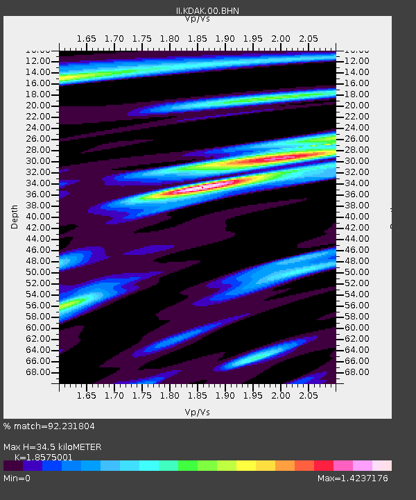
KDAK Kodiak Island, Alaska, USA - Earthquake Result Viewer

Earthquake location: Off East Coast Of Honshu, Japan
Earthquake latitude/longitude: 37.6/142.2
Earthquake time(UTC): 2008/07/19 (201) 02:39:28 GMT
Earthquake Depth: 22 km
Earthquake Magnitude: 6.2 MB, 7.0 MS, 7.0 MW, 6.9 MW
Earthquake Catalog/Contributor: WHDF/NEIC
Network: II Global Seismograph Network (GSN - IRIS/IDA)
Station: KDAK Kodiak Island, Alaska, USA
Lat/Lon: 57.78 N/152.58 W
Elevation: 152 m
Distance: 46.3 deg
Az: 42.283 deg
Baz: 273.462 deg
Ray Param: 0.070706815
Estimated Moho Depth: 34.5 km
Estimated Crust Vp/Vs: 1.86
Assumed Crust Vp: 6.134 km/s
Estimated Crust Vs: 3.302 km/s
Estimated Crust Poisson's Ratio: 0.30
Radial Match: 92.231804 %
Radial Bump: 400
Transverse Match: 81.34248 %
Transverse Bump: 400
SOD ConfigId: 2504
Insert Time: 2010-03-01 21:00:13.097 +0000
GWidth: 2.5
Max Bumps: 400
Tol: 0.001

Signal To Noise

ChannelStoNSTALTA
II:KDAK:00:BHN:20080719T02:47:21.749011Z6.9597041.2968479E-61.8633665E-7
II:KDAK:00:BHE:20080719T02:47:21.749011Z1.47632561.9329227E-71.3092794E-7
II:KDAK:00:BHZ:20080719T02:47:21.749011Z4.8162136.498165E-71.3492271E-7
Arrivals
Ps5.1 SECOND
PpPs15 SECOND
PsPs/PpSs20 SECOND