You are here: Home > Network List > II - Global Seismograph Network (GSN - IRIS/IDA) Stations List
> Station KDAK Kodiak Island, Alaska, USA > Earthquake Result Viewer
KDAK Kodiak Island, Alaska, USA - Earthquake Result Viewer

| Earthquake location: |
Eastern Honshu, Japan |
| Earthquake latitude/longitude: |
39.8/141.5 |
| Earthquake time(UTC): |
2008/07/23 (205) 15:26:19 GMT |
| Earthquake Depth: |
108 km |
| Earthquake Magnitude: |
6.6 MB, 6.8 MW, 6.8 MW |
| Earthquake Catalog/Contributor: |
WHDF/NEIC |
|
| Network: |
II Global Seismograph Network (GSN - IRIS/IDA) |
| Station: |
KDAK Kodiak Island, Alaska, USA |
| Lat/Lon: |
57.78 N/152.58 W |
| Elevation: |
152 m |
|
| Distance: |
45.0 deg |
| Az: |
43.733 deg |
| Baz: |
276.204 deg |
| Ray Param: |
0.071152925 |
| Estimated Moho Depth: |
33.75 km |
| Estimated Crust Vp/Vs: |
1.92 |
| Assumed Crust Vp: |
6.134 km/s |
| Estimated Crust Vs: |
3.191 km/s |
| Estimated Crust Poisson's Ratio: |
0.31 |
|
| Radial Match: |
96.07293 % |
| Radial Bump: |
373 |
| Transverse Match: |
86.108086 % |
| Transverse Bump: |
400 |
| SOD ConfigId: |
2504 |
| Insert Time: |
2010-03-01 21:00:30.283 +0000 |
| GWidth: |
2.5 |
| Max Bumps: |
400 |
| Tol: |
0.001 |
|
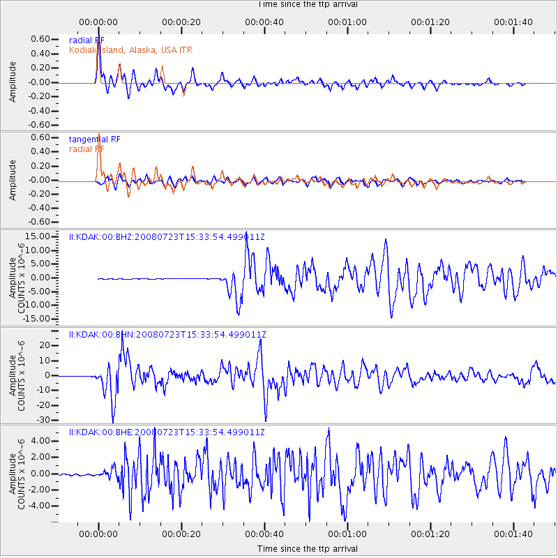
Signal To Noise
| Channel | StoN | STA | LTA |
| II:KDAK:00:BHN:20080723T15:33:54.499011Z | 100.15129 | 1.2085941E-5 | 1.2067684E-7 |
| II:KDAK:00:BHE:20080723T15:33:54.499011Z | 8.257281 | 5.4552635E-7 | 6.606609E-8 |
| II:KDAK:00:BHZ:20080723T15:33:54.499011Z | 58.27796 | 5.926853E-6 | 1.0169973E-7 |
| Arrivals |
| Ps | 5.4 SECOND |
| PpPs | 15 SECOND |
| PsPs/PpSs | 21 SECOND |


