You are here: Home > Network List > AU - Australian Seismological Centre Stations List
> Station KNRA Kunnunarra, Western Australia > Earthquake Result Viewer
KNRA Kunnunarra, Western Australia - Earthquake Result Viewer
| Earthquake location: |
Solomon Islands |
| Earthquake latitude/longitude: |
-11.3/161.8 |
| Earthquake time(UTC): |
2014/04/14 (104) 06:29:50 GMT |
| Earthquake Depth: |
35 km |
| Earthquake Magnitude: |
5.9 MWP |
| Earthquake Catalog/Contributor: |
NEIC PDE/NEIC COMCAT |
|
| Network: |
AU Australian Seismological Centre |
| Station: |
KNRA Kunnunarra, Western Australia |
| Lat/Lon: |
15.68 S/128.76 E |
| Elevation: |
101 m |
|
| Distance: |
32.4 deg |
| Az: |
258.521 deg |
| Baz: |
86.378 deg |
| Ray Param: |
0.078620486 |
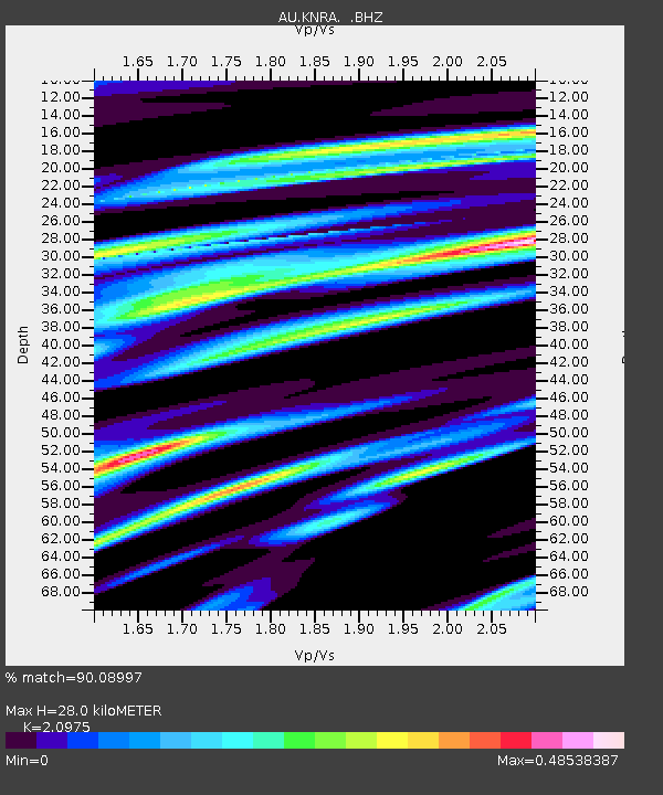
| Estimated Moho Depth: |
28.0 km |
| Estimated Crust Vp/Vs: |
2.10 |
| Assumed Crust Vp: |
6.397 km/s |
| Estimated Crust Vs: |
3.05 km/s |
| Estimated Crust Poisson's Ratio: |
0.35 |
|
| Radial Match: |
90.08997 % |
| Radial Bump: |
372 |
| Transverse Match: |
73.45182 % |
| Transverse Bump: |
400 |
| SOD ConfigId: |
626651 |
| Insert Time: |
2014-04-28 06:33:06.190 +0000 |
| GWidth: |
2.5 |
| Max Bumps: |
400 |
| Tol: |
0.001 |
|

Signal To Noise
| Channel | StoN | STA | LTA |
| AU:KNRA: :BHZ:20140414T06:35:46.843986Z | 4.251159 | 1.0664658E-6 | 2.508647E-7 |
| AU:KNRA: :BHN:20140414T06:35:46.843986Z | 1.0899358 | 2.406043E-7 | 2.2075089E-7 |
| AU:KNRA: :BHE:20140414T06:35:46.843986Z | 1.8656312 | 5.411799E-7 | 2.900787E-7 |
| Arrivals |
| Ps | 5.1 SECOND |
| PpPs | 13 SECOND |
| PsPs/PpSs | 18 SECOND |


