You are here: Home > Network List > II - Global Seismograph Network (GSN - IRIS/IDA) Stations List
> Station KDAK Kodiak Island, Alaska, USA > Earthquake Result Viewer
KDAK Kodiak Island, Alaska, USA - Earthquake Result Viewer
| Earthquake location: |
Banda Sea |
| Earthquake latitude/longitude: |
-5.9/130.2 |
| Earthquake time(UTC): |
2008/08/04 (217) 20:45:13 GMT |
| Earthquake Depth: |
174 km |
| Earthquake Magnitude: |
6.1 MB, 6.3 MW, 6.2 MW |
| Earthquake Catalog/Contributor: |
WHDF/NEIC |
|
| Network: |
II Global Seismograph Network (GSN - IRIS/IDA) |
| Station: |
KDAK Kodiak Island, Alaska, USA |
| Lat/Lon: |
57.78 N/152.58 W |
| Elevation: |
152 m |
|
| Distance: |
88.2 deg |
| Az: |
31.513 deg |
| Baz: |
256.069 deg |
| Ray Param: |
0.042366255 |
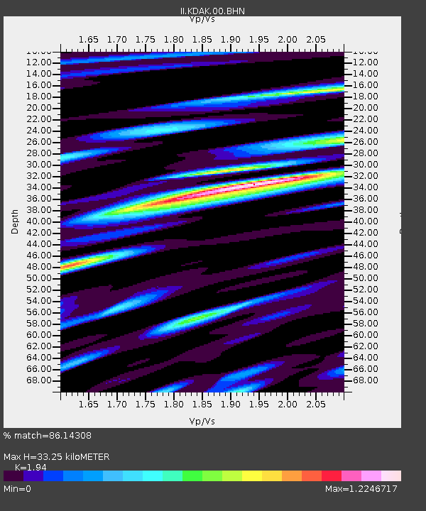
| Estimated Moho Depth: |
33.25 km |
| Estimated Crust Vp/Vs: |
1.94 |
| Assumed Crust Vp: |
6.134 km/s |
| Estimated Crust Vs: |
3.162 km/s |
| Estimated Crust Poisson's Ratio: |
0.32 |
|
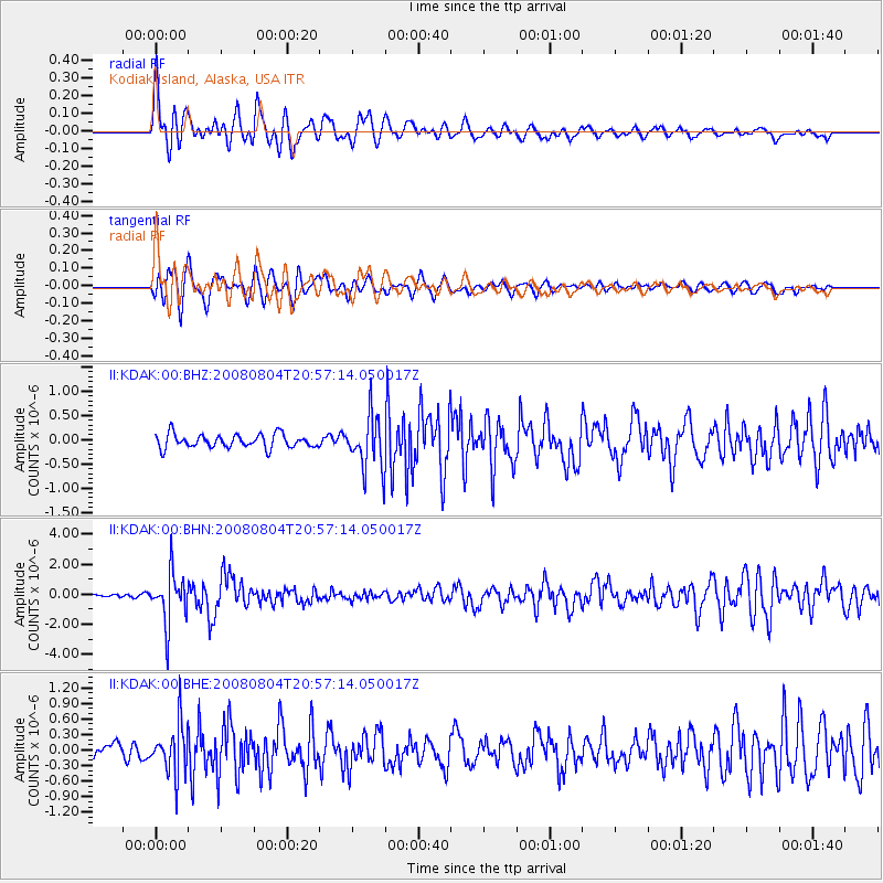
| Radial Match: |
86.14308 % |
| Radial Bump: |
400 |
| Transverse Match: |
79.34079 % |
| Transverse Bump: |
400 |
| SOD ConfigId: |
2504 |
| Insert Time: |
2010-03-01 21:00:43.668 +0000 |
| GWidth: |
2.5 |
| Max Bumps: |
400 |
| Tol: |
0.001 |
|
Signal To Noise
| Channel | StoN | STA | LTA |
| II:KDAK:00:BHN:20080804T20:57:14.050017Z | 12.736252 | 1.6609188E-6 | 1.3040875E-7 |
| II:KDAK:00:BHE:20080804T20:57:14.050017Z | 2.6866906 | 4.606251E-7 | 1.7144703E-7 |
| II:KDAK:00:BHZ:20080804T20:57:14.050017Z | 3.9641733 | 5.5665606E-7 | 1.4042173E-7 |
| Arrivals |
| Ps | 5.2 SECOND |
| PpPs | 16 SECOND |
| PsPs/PpSs | 21 SECOND |


