You are here: Home > Network List > II - Global Seismograph Network (GSN - IRIS/IDA) Stations List
> Station KAPI Kappang, Sulawesi, Indonesia > Earthquake Result Viewer
KAPI Kappang, Sulawesi, Indonesia - Earthquake Result Viewer
| Earthquake location: |
Solomon Islands |
| Earthquake latitude/longitude: |
-11.3/161.8 |
| Earthquake time(UTC): |
2014/04/14 (104) 06:29:50 GMT |
| Earthquake Depth: |
35 km |
| Earthquake Magnitude: |
5.9 MWP |
| Earthquake Catalog/Contributor: |
NEIC PDE/NEIC COMCAT |
|
| Network: |
II Global Seismograph Network (GSN - IRIS/IDA) |
| Station: |
KAPI Kappang, Sulawesi, Indonesia |
| Lat/Lon: |
5.01 S/119.75 E |
| Elevation: |
300 m |
|
| Distance: |
42.0 deg |
| Az: |
275.014 deg |
| Baz: |
101.211 deg |
| Ray Param: |
0.073341735 |
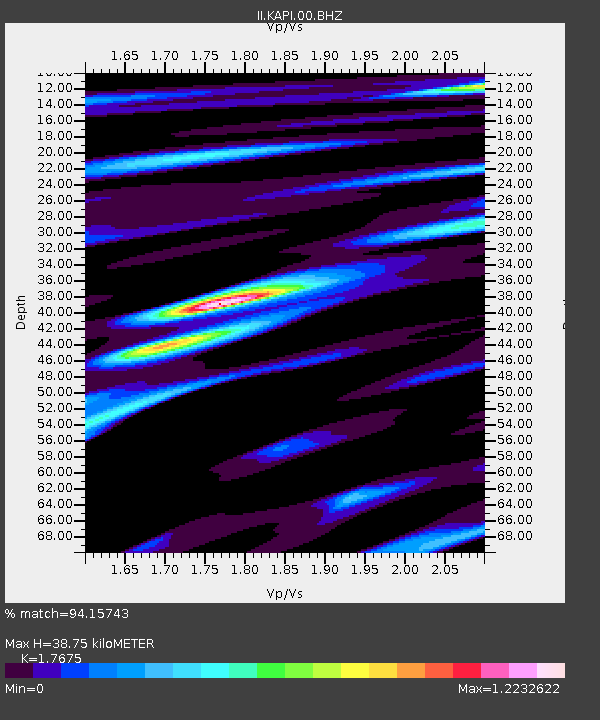
| Estimated Moho Depth: |
38.75 km |
| Estimated Crust Vp/Vs: |
1.77 |
| Assumed Crust Vp: |
6.343 km/s |
| Estimated Crust Vs: |
3.589 km/s |
| Estimated Crust Poisson's Ratio: |
0.26 |
|
| Radial Match: |
94.15743 % |
| Radial Bump: |
389 |
| Transverse Match: |
81.313705 % |
| Transverse Bump: |
400 |
| SOD ConfigId: |
626651 |
| Insert Time: |
2014-04-28 06:37:06.098 +0000 |
| GWidth: |
2.5 |
| Max Bumps: |
400 |
| Tol: |
0.001 |
|
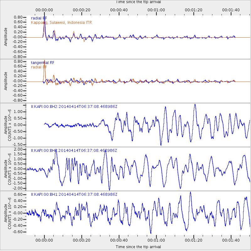
Signal To Noise
| Channel | StoN | STA | LTA |
| II:KAPI:00:BHZ:20140414T06:37:08.468986Z | 5.3888454 | 4.2658695E-7 | 7.9161104E-8 |
| II:KAPI:00:BH1:20140414T06:37:08.468986Z | 1.6538628 | 9.951583E-8 | 6.017175E-8 |
| II:KAPI:00:BH2:20140414T06:37:08.468986Z | 3.31681 | 2.458511E-7 | 7.412277E-8 |
| Arrivals |
| Ps | 5.0 SECOND |
| PpPs | 16 SECOND |
| PsPs/PpSs | 21 SECOND |


