You are here: Home > Network List > II - Global Seismograph Network (GSN - IRIS/IDA) Stations List
> Station KDAK Kodiak Island, Alaska, USA > Earthquake Result Viewer
KDAK Kodiak Island, Alaska, USA - Earthquake Result Viewer
| Earthquake location: |
Xizang |
| Earthquake latitude/longitude: |
29.8/90.3 |
| Earthquake time(UTC): |
2008/10/06 (280) 08:30:45 GMT |
| Earthquake Depth: |
12 km |
| Earthquake Magnitude: |
6.0 MB, 6.2 MS, 6.3 MW, 6.3 MW |
| Earthquake Catalog/Contributor: |
WHDF/NEIC |
|
| Network: |
II Global Seismograph Network (GSN - IRIS/IDA) |
| Station: |
KDAK Kodiak Island, Alaska, USA |
| Lat/Lon: |
57.78 N/152.58 W |
| Elevation: |
152 m |
|
| Distance: |
78.1 deg |
| Az: |
29.173 deg |
| Baz: |
307.733 deg |
| Ray Param: |
0.049850438 |
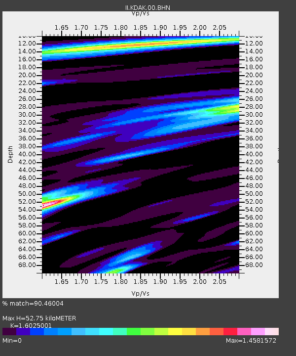
| Estimated Moho Depth: |
52.75 km |
| Estimated Crust Vp/Vs: |
1.60 |
| Assumed Crust Vp: |
6.134 km/s |
| Estimated Crust Vs: |
3.828 km/s |
| Estimated Crust Poisson's Ratio: |
0.18 |
|
| Radial Match: |
90.46004 % |
| Radial Bump: |
400 |
| Transverse Match: |
76.38511 % |
| Transverse Bump: |
400 |
| SOD ConfigId: |
2556 |
| Insert Time: |
2010-03-01 21:00:56.482 +0000 |
| GWidth: |
2.5 |
| Max Bumps: |
400 |
| Tol: |
0.001 |
|

Signal To Noise
| Channel | StoN | STA | LTA |
| II:KDAK:00:BHN:20081006T08:42:12.999016Z | 12.076663 | 1.6425311E-6 | 1.360087E-7 |
| II:KDAK:00:BHE:20081006T08:42:12.999016Z | 3.1312778 | 3.218762E-7 | 1.02793884E-7 |
| II:KDAK:00:BHZ:20081006T08:42:12.999016Z | 2.8977292 | 4.295785E-7 | 1.482466E-7 |
| Arrivals |
| Ps | 5.3 SECOND |
| PpPs | 22 SECOND |
| PsPs/PpSs | 27 SECOND |


