You are here: Home > Network List > II - Global Seismograph Network (GSN - IRIS/IDA) Stations List
> Station KDAK Kodiak Island, Alaska, USA > Earthquake Result Viewer
KDAK Kodiak Island, Alaska, USA - Earthquake Result Viewer
| Earthquake location: |
Tonga Islands |
| Earthquake latitude/longitude: |
-21.9/-173.8 |
| Earthquake time(UTC): |
2008/10/19 (293) 05:10:33 GMT |
| Earthquake Depth: |
29 km |
| Earthquake Magnitude: |
6.8 MB, 7.0 MS, 6.9 MW, 6.9 MW |
| Earthquake Catalog/Contributor: |
WHDF/NEIC |
|
| Network: |
II Global Seismograph Network (GSN - IRIS/IDA) |
| Station: |
KDAK Kodiak Island, Alaska, USA |
| Lat/Lon: |
57.78 N/152.58 W |
| Elevation: |
152 m |
|
| Distance: |
81.3 deg |
| Az: |
11.32 deg |
| Baz: |
199.9 deg |
| Ray Param: |
0.047644347 |
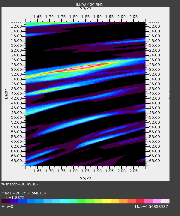
| Estimated Moho Depth: |
28.75 km |
| Estimated Crust Vp/Vs: |
1.84 |
| Assumed Crust Vp: |
6.134 km/s |
| Estimated Crust Vs: |
3.338 km/s |
| Estimated Crust Poisson's Ratio: |
0.29 |
|
| Radial Match: |
88.49087 % |
| Radial Bump: |
400 |
| Transverse Match: |
75.74761 % |
| Transverse Bump: |
376 |
| SOD ConfigId: |
2556 |
| Insert Time: |
2010-03-01 21:01:00.659 +0000 |
| GWidth: |
2.5 |
| Max Bumps: |
400 |
| Tol: |
0.001 |
|
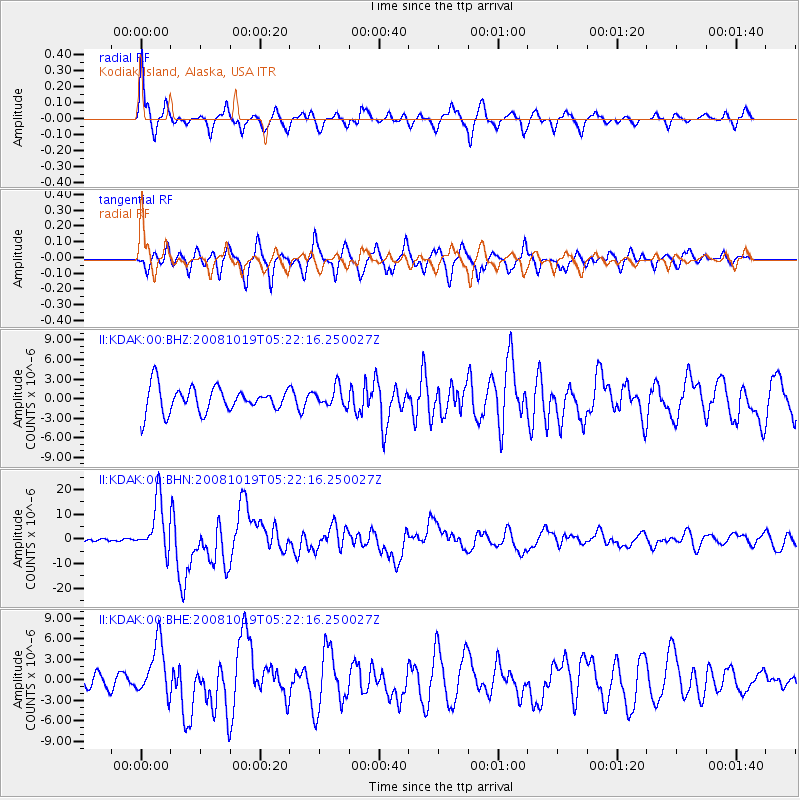
Signal To Noise
| Channel | StoN | STA | LTA |
| II:KDAK:00:BHN:20081019T05:22:16.250027Z | 9.70711 | 1.0593513E-5 | 1.0913149E-6 |
| II:KDAK:00:BHE:20081019T05:22:16.250027Z | 2.953215 | 3.895919E-6 | 1.3192127E-6 |
| II:KDAK:00:BHZ:20081019T05:22:16.250027Z | 0.7837323 | 1.5175394E-6 | 1.936298E-6 |
| Arrivals |
| Ps | 4.0 SECOND |
| PpPs | 13 SECOND |
| PsPs/PpSs | 17 SECOND |


