You are here: Home > Network List > KN - Kyrgyz Seismic Telemetry Network Stations List
> Station CHM KN.CHM > Earthquake Result Viewer
CHM KN.CHM - Earthquake Result Viewer
*The percent match for this event was below the threshold and hence no stack was calculated.
| Earthquake location: |
Mindoro, Philippines |
| Earthquake latitude/longitude: |
14.0/120.6 |
| Earthquake time(UTC): |
2015/02/10 (041) 16:09:24 GMT |
| Earthquake Depth: |
134 km |
| Earthquake Magnitude: |
5.2 MW |
| Earthquake Catalog/Contributor: |
ISC/ISC |
|
| Network: |
KN Kyrgyz Seismic Telemetry Network |
| Station: |
CHM KN.CHM |
| Lat/Lon: |
43.00 N/74.75 E |
| Elevation: |
655 m |
|
| Distance: |
48.8 deg |
| Az: |
315.596 deg |
| Baz: |
112.186 deg |
| Ray Param: |
$rayparam |
*The percent match for this event was below the threshold and hence was not used in the summary stack. |
|
| Radial Match: |
59.445393 % |
| Radial Bump: |
400 |
| Transverse Match: |
62.15267 % |
| Transverse Bump: |
400 |
| SOD ConfigId: |
7019011 |
| Insert Time: |
2019-04-16 17:48:18.645 +0000 |
| GWidth: |
2.5 |
| Max Bumps: |
400 |
| Tol: |
0.001 |
|
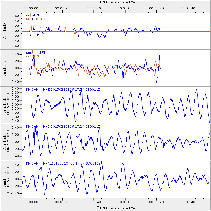
Signal To Noise
| Channel | StoN | STA | LTA |
| KN:CHM: :HHZ:20150210T16:17:24.930011Z | 1.4876286 | 2.835877E-7 | 1.9063071E-7 |
| KN:CHM: :HHN:20150210T16:17:24.930011Z | 0.59847534 | 1.6956915E-7 | 2.8333523E-7 |
| KN:CHM: :HHE:20150210T16:17:24.930011Z | 1.6589143 | 2.272802E-7 | 1.3700537E-7 |
| Arrivals |
| Ps | |
| PpPs | |
| PsPs/PpSs | |


