You are here: Home > Network List > II - Global Seismograph Network (GSN - IRIS/IDA) Stations List
> Station KDAK Kodiak Island, Alaska, USA > Earthquake Result Viewer
KDAK Kodiak Island, Alaska, USA - Earthquake Result Viewer

| Earthquake location: |
Pakistan |
| Earthquake latitude/longitude: |
30.6/67.4 |
| Earthquake time(UTC): |
2008/10/28 (302) 23:09:57 GMT |
| Earthquake Depth: |
15 km |
| Earthquake Magnitude: |
6.3 MB, 6.6 MS, 6.4 MW, 6.4 MW |
| Earthquake Catalog/Contributor: |
WHDF/NEIC |
|
| Network: |
II Global Seismograph Network (GSN - IRIS/IDA) |
| Station: |
KDAK Kodiak Island, Alaska, USA |
| Lat/Lon: |
57.78 N/152.58 W |
| Elevation: |
152 m |
|
| Distance: |
85.7 deg |
| Az: |
20.171 deg |
| Baz: |
326.304 deg |
| Ray Param: |
0.044534367 |
| Estimated Moho Depth: |
31.0 km |
| Estimated Crust Vp/Vs: |
1.82 |
| Assumed Crust Vp: |
6.134 km/s |
| Estimated Crust Vs: |
3.366 km/s |
| Estimated Crust Poisson's Ratio: |
0.28 |
|
| Radial Match: |
83.51353 % |
| Radial Bump: |
400 |
| Transverse Match: |
75.29187 % |
| Transverse Bump: |
400 |
| SOD ConfigId: |
2560 |
| Insert Time: |
2010-03-01 21:01:11.280 +0000 |
| GWidth: |
2.5 |
| Max Bumps: |
400 |
| Tol: |
0.001 |
|
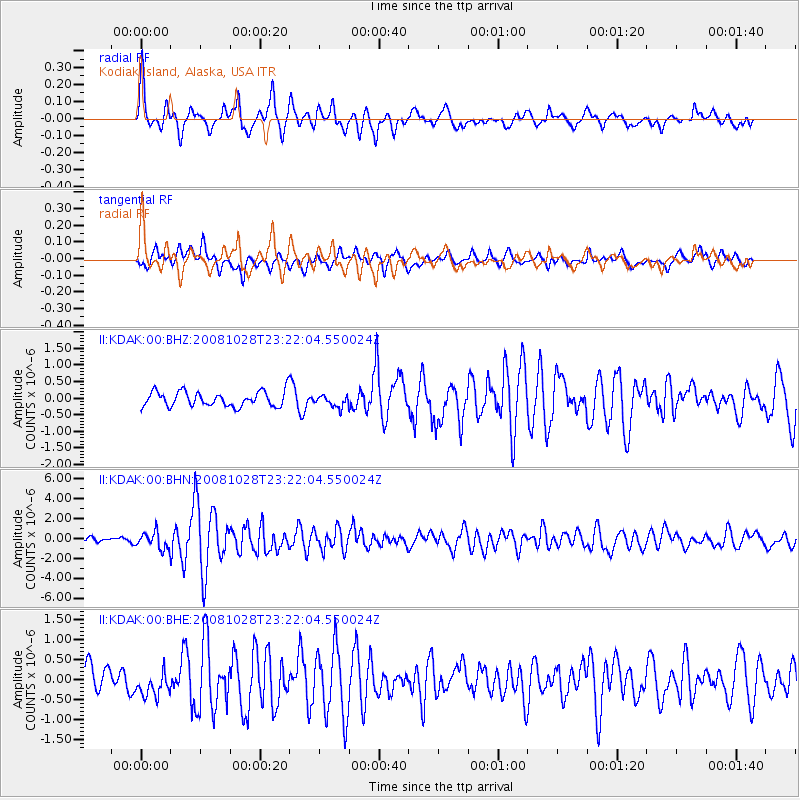
Signal To Noise
| Channel | StoN | STA | LTA |
| II:KDAK:00:BHN:20081028T23:22:04.550024Z | 3.8821187 | 8.4558457E-7 | 2.1781523E-7 |
| II:KDAK:00:BHE:20081028T23:22:04.550024Z | 0.96215314 | 3.159958E-7 | 3.284257E-7 |
| II:KDAK:00:BHZ:20081028T23:22:04.550024Z | 0.7912249 | 1.797675E-7 | 2.2720151E-7 |
| Arrivals |
| Ps | 4.2 SECOND |
| PpPs | 14 SECOND |
| PsPs/PpSs | 18 SECOND |


