You are here: Home > Network List > IU - Global Seismograph Network (GSN - IRIS/USGS) Stations List
> Station RSSD Black Hills, South Dakota, USA > Earthquake Result Viewer
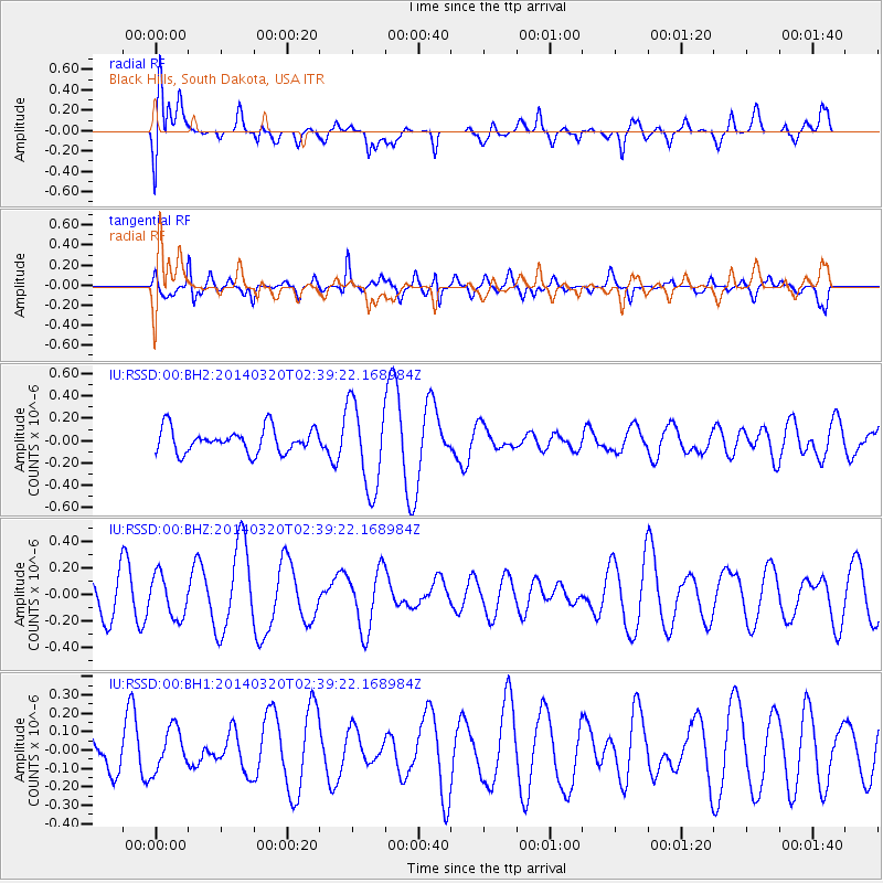
RSSD Black Hills, South Dakota, USA - Earthquake Result Viewer
*The percent match for this event was below the threshold and hence no stack was calculated.
| Earthquake location: |
South Of Tonga Islands |
| Earthquake latitude/longitude: |
-24.2/-175.0 |
| Earthquake time(UTC): |
2014/03/20 (079) 02:26:37 GMT |
| Earthquake Depth: |
22 km |
| Earthquake Magnitude: |
6.7 MB |
| Earthquake Catalog/Contributor: |
NEIC PDE/NEIC COMCAT |
|
| Network: |
IU Global Seismograph Network (GSN - IRIS/USGS) |
| Station: |
RSSD Black Hills, South Dakota, USA |
| Lat/Lon: |
44.12 N/104.04 W |
| Elevation: |
2090 m |
|
| Distance: |
93.9 deg |
| Az: |
43.049 deg |
| Baz: |
239.937 deg |
| Ray Param: |
$rayparam |
*The percent match for this event was below the threshold and hence was not used in the summary stack. |
|
| Radial Match: |
45.92922 % |
| Radial Bump: |
400 |
| Transverse Match: |
69.0606 % |
| Transverse Bump: |
398 |
| SOD ConfigId: |
626651 |
| Insert Time: |
2014-04-29 00:24:37.864 +0000 |
| GWidth: |
2.5 |
| Max Bumps: |
400 |
| Tol: |
0.001 |
|
Signal To Noise
| Channel | StoN | STA | LTA |
| IU:RSSD:00:BHZ:20140320T02:39:22.168984Z | 0.94600177 | 1.5864322E-7 | 1.6769866E-7 |
| IU:RSSD:00:BH1:20140320T02:39:22.168984Z | 0.9851579 | 1.1413858E-7 | 1.15858164E-7 |
| IU:RSSD:00:BH2:20140320T02:39:22.168984Z | 3.606008 | 3.8751162E-7 | 1.0746277E-7 |
| Arrivals |
| Ps | |
| PpPs | |
| PsPs/PpSs | |


