You are here: Home > Network List > TA - USArray Transportable Network (new EarthScope stations) Stations List
> Station Q24A Divide, CO, USA > Earthquake Result Viewer
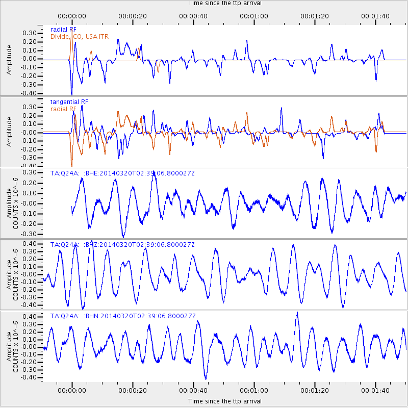
Q24A Divide, CO, USA - Earthquake Result Viewer
*The percent match for this event was below the threshold and hence no stack was calculated.
| Earthquake location: |
South Of Tonga Islands |
| Earthquake latitude/longitude: |
-24.2/-175.0 |
| Earthquake time(UTC): |
2014/03/20 (079) 02:26:37 GMT |
| Earthquake Depth: |
22 km |
| Earthquake Magnitude: |
6.7 MB |
| Earthquake Catalog/Contributor: |
NEIC PDE/NEIC COMCAT |
|
| Network: |
TA USArray Transportable Network (new EarthScope stations) |
| Station: |
Q24A Divide, CO, USA |
| Lat/Lon: |
38.96 N/105.15 W |
| Elevation: |
2775 m |
|
| Distance: |
90.6 deg |
| Az: |
47.066 deg |
| Baz: |
239.041 deg |
| Ray Param: |
$rayparam |
*The percent match for this event was below the threshold and hence was not used in the summary stack. |
|
| Radial Match: |
55.441517 % |
| Radial Bump: |
400 |
| Transverse Match: |
50.53016 % |
| Transverse Bump: |
400 |
| SOD ConfigId: |
626651 |
| Insert Time: |
2014-04-29 00:28:31.754 +0000 |
| GWidth: |
2.5 |
| Max Bumps: |
400 |
| Tol: |
0.001 |
|
Signal To Noise
| Channel | StoN | STA | LTA |
| TA:Q24A: :BHZ:20140320T02:39:06.800027Z | 1.7225261 | 2.8413353E-7 | 1.6495167E-7 |
| TA:Q24A: :BHN:20140320T02:39:06.800027Z | 1.5212123 | 1.9781396E-7 | 1.3003705E-7 |
| TA:Q24A: :BHE:20140320T02:39:06.800027Z | 0.63816965 | 8.957244E-8 | 1.4035834E-7 |
| Arrivals |
| Ps | |
| PpPs | |
| PsPs/PpSs | |


