You are here: Home > Network List > II - Global Seismograph Network (GSN - IRIS/IDA) Stations List
> Station KDAK Kodiak Island, Alaska, USA > Earthquake Result Viewer
KDAK Kodiak Island, Alaska, USA - Earthquake Result Viewer
| Earthquake location: |
Banda Sea |
| Earthquake latitude/longitude: |
-6.6/130.9 |
| Earthquake time(UTC): |
1997/07/31 (212) 21:54:21 GMT |
| Earthquake Depth: |
59 km |
| Earthquake Magnitude: |
5.9 MB, 5.3 MS, 6.1 UNKNOWN, 6.1 MW |
| Earthquake Catalog/Contributor: |
WHDF/NEIC |
|
| Network: |
II Global Seismograph Network (GSN - IRIS/IDA) |
| Station: |
KDAK Kodiak Island, Alaska, USA |
| Lat/Lon: |
57.78 N/152.58 W |
| Elevation: |
152 m |
|
| Distance: |
88.4 deg |
| Az: |
31.405 deg |
| Baz: |
255.082 deg |
| Ray Param: |
0.042482145 |
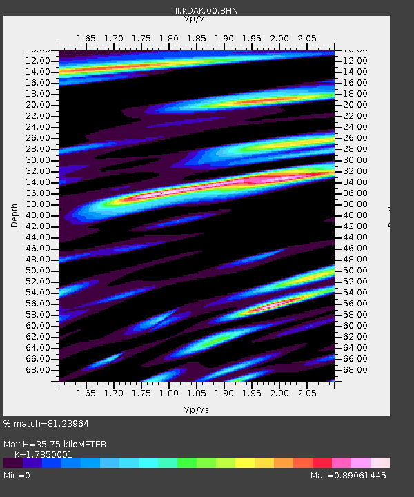
| Estimated Moho Depth: |
35.75 km |
| Estimated Crust Vp/Vs: |
1.79 |
| Assumed Crust Vp: |
6.134 km/s |
| Estimated Crust Vs: |
3.436 km/s |
| Estimated Crust Poisson's Ratio: |
0.27 |
|
| Radial Match: |
81.23964 % |
| Radial Bump: |
400 |
| Transverse Match: |
61.22087 % |
| Transverse Bump: |
400 |
| SOD ConfigId: |
6273 |
| Insert Time: |
2010-03-01 21:01:25.877 +0000 |
| GWidth: |
2.5 |
| Max Bumps: |
400 |
| Tol: |
0.001 |
|

Signal To Noise
| Channel | StoN | STA | LTA |
| II:KDAK:00:BHN:19970731T22:06:36.075012Z | 1.1211021 | 1.0101679E-7 | 9.01049E-8 |
| II:KDAK:00:BHE:19970731T22:06:36.075012Z | 1.6280682 | 1.504125E-7 | 9.2387104E-8 |
| II:KDAK:00:BHZ:19970731T22:06:36.075012Z | 4.166099 | 3.6664125E-7 | 8.800588E-8 |
| Arrivals |
| Ps | 4.7 SECOND |
| PpPs | 16 SECOND |
| PsPs/PpSs | 21 SECOND |


