You are here: Home > Network List > II - Global Seismograph Network (GSN - IRIS/IDA) Stations List
> Station KDAK Kodiak Island, Alaska, USA > Earthquake Result Viewer
KDAK Kodiak Island, Alaska, USA - Earthquake Result Viewer

| Earthquake location: |
South Of Fiji Islands |
| Earthquake latitude/longitude: |
-26.6/178.3 |
| Earthquake time(UTC): |
1997/09/04 (247) 04:23:37 GMT |
| Earthquake Depth: |
625 km |
| Earthquake Magnitude: |
6.3 MB, 6.8 UNKNOWN, 6.5 ME |
| Earthquake Catalog/Contributor: |
WHDF/NEIC |
|
| Network: |
II Global Seismograph Network (GSN - IRIS/IDA) |
| Station: |
KDAK Kodiak Island, Alaska, USA |
| Lat/Lon: |
57.78 N/152.58 W |
| Elevation: |
152 m |
|
| Distance: |
87.5 deg |
| Az: |
15.107 deg |
| Baz: |
205.83 deg |
| Ray Param: |
0.04170717 |
| Estimated Moho Depth: |
29.5 km |
| Estimated Crust Vp/Vs: |
1.85 |
| Assumed Crust Vp: |
6.134 km/s |
| Estimated Crust Vs: |
3.311 km/s |
| Estimated Crust Poisson's Ratio: |
0.29 |
|
| Radial Match: |
89.20529 % |
| Radial Bump: |
400 |
| Transverse Match: |
81.89462 % |
| Transverse Bump: |
400 |
| SOD ConfigId: |
6273 |
| Insert Time: |
2010-03-01 21:01:30.341 +0000 |
| GWidth: |
2.5 |
| Max Bumps: |
400 |
| Tol: |
0.001 |
|
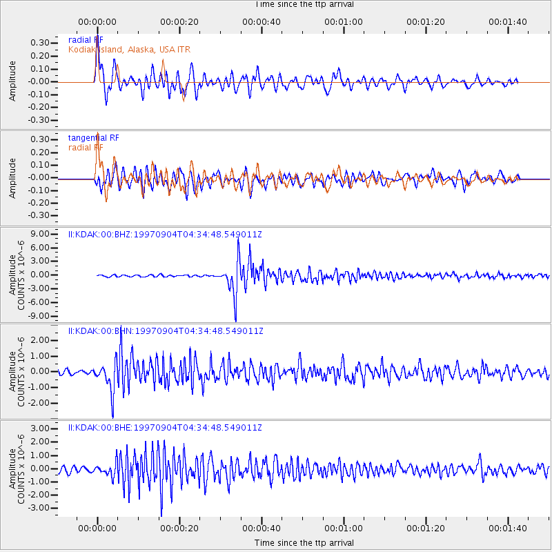
Signal To Noise
| Channel | StoN | STA | LTA |
| II:KDAK:00:BHN:19970904T04:34:48.549011Z | 5.615733 | 9.385789E-7 | 1.6713382E-7 |
| II:KDAK:00:BHE:19970904T04:34:48.549011Z | 2.3745515 | 4.800434E-7 | 2.0216173E-7 |
| II:KDAK:00:BHZ:19970904T04:34:48.549011Z | 18.727205 | 3.6644476E-6 | 1.9567509E-7 |
| Arrivals |
| Ps | 4.2 SECOND |
| PpPs | 13 SECOND |
| PsPs/PpSs | 18 SECOND |


