You are here: Home > Network List > II - Global Seismograph Network (GSN - IRIS/IDA) Stations List
> Station KDAK Kodiak Island, Alaska, USA > Earthquake Result Viewer
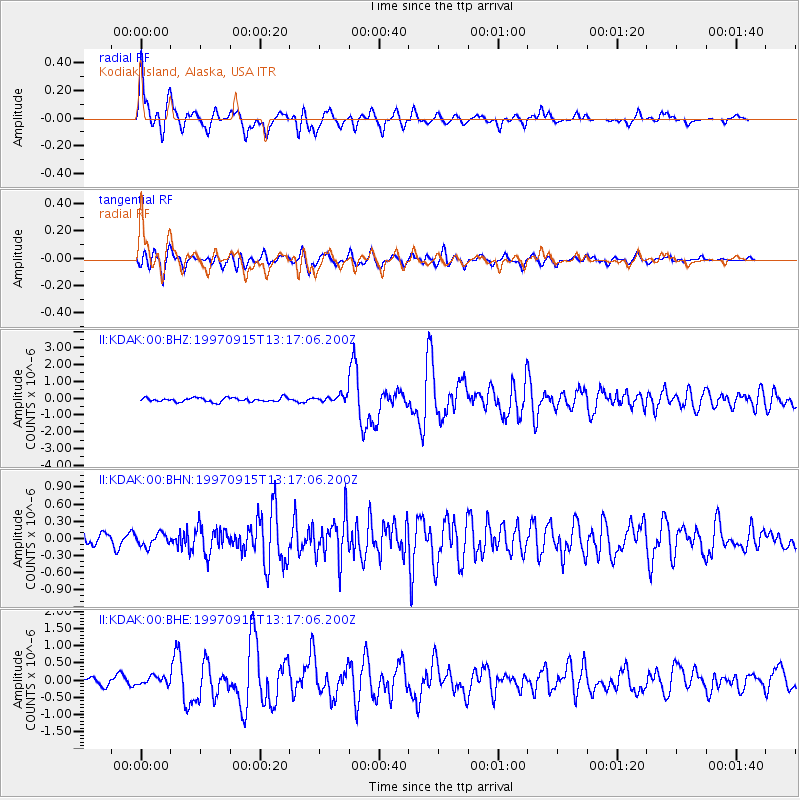
KDAK Kodiak Island, Alaska, USA - Earthquake Result Viewer

| Earthquake location: |
Mindanao, Philippines |
| Earthquake latitude/longitude: |
8.1/126.6 |
| Earthquake time(UTC): |
1997/09/15 (258) 13:05:42 GMT |
| Earthquake Depth: |
51 km |
| Earthquake Magnitude: |
5.8 MB, 5.7 MS, 6.1 UNKNOWN, 6.1 MW |
| Earthquake Catalog/Contributor: |
WHDF/NEIC |
|
| Network: |
II Global Seismograph Network (GSN - IRIS/IDA) |
| Station: |
KDAK Kodiak Island, Alaska, USA |
| Lat/Lon: |
57.78 N/152.58 W |
| Elevation: |
152 m |
|
| Distance: |
78.3 deg |
| Az: |
32.686 deg |
| Baz: |
266.541 deg |
| Ray Param: |
0.049658753 |
| Estimated Moho Depth: |
36.25 km |
| Estimated Crust Vp/Vs: |
1.82 |
| Assumed Crust Vp: |
6.134 km/s |
| Estimated Crust Vs: |
3.366 km/s |
| Estimated Crust Poisson's Ratio: |
0.28 |
|
| Radial Match: |
89.92793 % |
| Radial Bump: |
363 |
| Transverse Match: |
85.98332 % |
| Transverse Bump: |
400 |
| SOD ConfigId: |
6273 |
| Insert Time: |
2010-03-01 21:01:34.352 +0000 |
| GWidth: |
2.5 |
| Max Bumps: |
400 |
| Tol: |
0.001 |
|
Signal To Noise
| Channel | StoN | STA | LTA |
| II:KDAK:00:BHN:19970915T13:17:06.200Z | 1.2114509 | 1.08459304E-7 | 8.9528434E-8 |
| II:KDAK:00:BHE:19970915T13:17:06.200Z | 1.0530064 | 1.1736337E-7 | 1.1145551E-7 |
| II:KDAK:00:BHZ:19970915T13:17:06.200Z | 1.6306962 | 1.9435814E-7 | 1.19187206E-7 |
| Arrivals |
| Ps | 5.0 SECOND |
| PpPs | 16 SECOND |
| PsPs/PpSs | 21 SECOND |


