You are here: Home > Network List > UW - Pacific Northwest Regional Seismic Network Stations List
> Station HOOD Mt Hood Meadows, OR CREST BB SMO > Earthquake Result Viewer
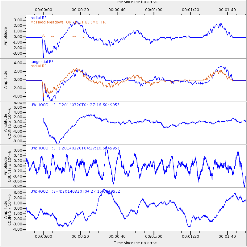
HOOD Mt Hood Meadows, OR CREST BB SMO - Earthquake Result Viewer
*The percent match for this event was below the threshold and hence no stack was calculated.
| Earthquake location: |
New Ireland Region, P.N.G. |
| Earthquake latitude/longitude: |
-5.5/153.7 |
| Earthquake time(UTC): |
2014/03/20 (079) 04:14:46 GMT |
| Earthquake Depth: |
1.0 km |
| Earthquake Magnitude: |
5.5 MB |
| Earthquake Catalog/Contributor: |
NEIC PDE/NEIC COMCAT |
|
| Network: |
UW Pacific Northwest Regional Seismic Network |
| Station: |
HOOD Mt Hood Meadows, OR CREST BB SMO |
| Lat/Lon: |
45.32 N/121.65 W |
| Elevation: |
1520 m |
|
| Distance: |
90.1 deg |
| Az: |
44.625 deg |
| Baz: |
262.397 deg |
| Ray Param: |
$rayparam |
*The percent match for this event was below the threshold and hence was not used in the summary stack. |
|
| Radial Match: |
38.633343 % |
| Radial Bump: |
400 |
| Transverse Match: |
48.75775 % |
| Transverse Bump: |
400 |
| SOD ConfigId: |
626651 |
| Insert Time: |
2014-04-29 02:48:27.633 +0000 |
| GWidth: |
2.5 |
| Max Bumps: |
400 |
| Tol: |
0.001 |
|
Signal To Noise
| Channel | StoN | STA | LTA |
| UW:HOOD: :BHZ:20140320T04:27:16.604995Z | 0.793207 | 2.8530746E-7 | 3.5968853E-7 |
| UW:HOOD: :BHN:20140320T04:27:16.604995Z | 1.6776786 | 3.885759E-6 | 2.3161522E-6 |
| UW:HOOD: :BHE:20140320T04:27:16.604995Z | 1.0488881 | 3.959052E-6 | 3.7745228E-6 |
| Arrivals |
| Ps | |
| PpPs | |
| PsPs/PpSs | |


