You are here: Home > Network List > G - GEOSCOPE Stations List
> Station MPG Montagne des Peres, French Guyana > Earthquake Result Viewer
MPG Montagne des Peres, French Guyana - Earthquake Result Viewer
| Earthquake location: |
Bouvet Island Region |
| Earthquake latitude/longitude: |
-53.5/8.7 |
| Earthquake time(UTC): |
2014/04/15 (105) 03:57:02 GMT |
| Earthquake Depth: |
12 km |
| Earthquake Magnitude: |
6.9 MWP, 6.8 MI, 6.9 MI |
| Earthquake Catalog/Contributor: |
NEIC PDE/NEIC COMCAT |
|
| Network: |
G GEOSCOPE |
| Station: |
MPG Montagne des Peres, French Guyana |
| Lat/Lon: |
5.11 N/52.64 W |
| Elevation: |
147 m |
|
| Distance: |
77.6 deg |
| Az: |
296.508 deg |
| Baz: |
147.564 deg |
| Ray Param: |
0.050186336 |
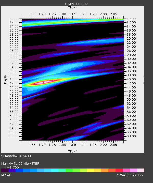
| Estimated Moho Depth: |
41.25 km |
| Estimated Crust Vp/Vs: |
1.71 |
| Assumed Crust Vp: |
6.472 km/s |
| Estimated Crust Vs: |
3.796 km/s |
| Estimated Crust Poisson's Ratio: |
0.24 |
|
| Radial Match: |
94.5483 % |
| Radial Bump: |
354 |
| Transverse Match: |
80.1817 % |
| Transverse Bump: |
400 |
| SOD ConfigId: |
626651 |
| Insert Time: |
2014-04-29 04:23:52.784 +0000 |
| GWidth: |
2.5 |
| Max Bumps: |
400 |
| Tol: |
0.001 |
|
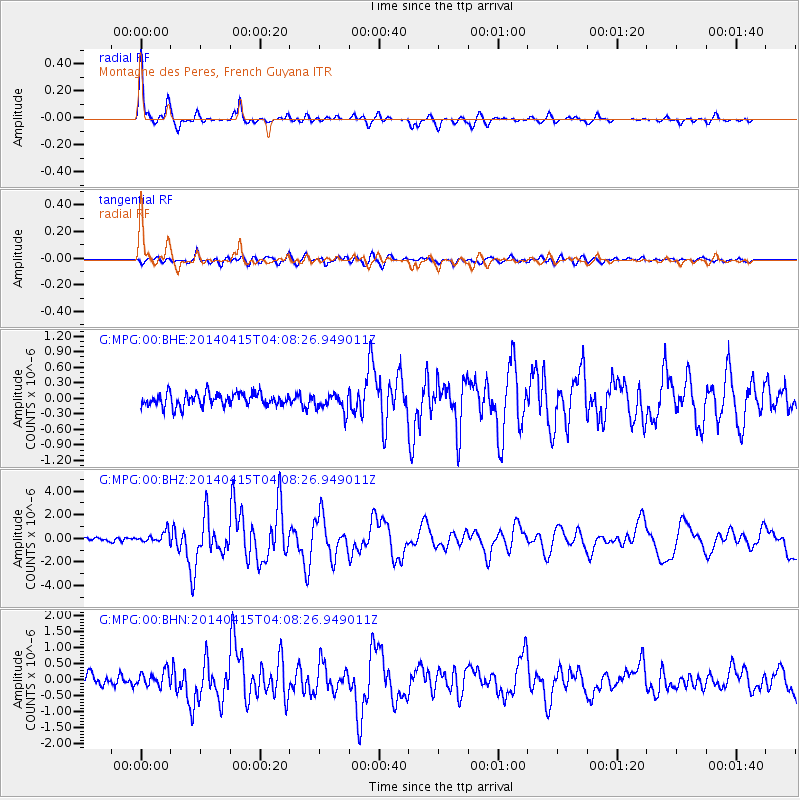
Signal To Noise
| Channel | StoN | STA | LTA |
| G:MPG:00:BHZ:20140415T04:08:26.949011Z | 1.9765321 | 4.6228757E-7 | 2.3388822E-7 |
| G:MPG:00:BHN:20140415T04:08:26.949011Z | 1.3855686 | 2.3281318E-7 | 1.6802717E-7 |
| G:MPG:00:BHE:20140415T04:08:26.949011Z | 1.3538749 | 1.7317898E-7 | 1.2791357E-7 |
| Arrivals |
| Ps | 4.6 SECOND |
| PpPs | 17 SECOND |
| PsPs/PpSs | 21 SECOND |


