You are here: Home > Network List > G - GEOSCOPE Stations List
> Station TAM Tamanrasset, Algeria > Earthquake Result Viewer
TAM Tamanrasset, Algeria - Earthquake Result Viewer
| Earthquake location: |
Bouvet Island Region |
| Earthquake latitude/longitude: |
-53.5/8.7 |
| Earthquake time(UTC): |
2014/04/15 (105) 03:57:02 GMT |
| Earthquake Depth: |
12 km |
| Earthquake Magnitude: |
6.9 MWP, 6.8 MI, 6.9 MI |
| Earthquake Catalog/Contributor: |
NEIC PDE/NEIC COMCAT |
|
| Network: |
G GEOSCOPE |
| Station: |
TAM Tamanrasset, Algeria |
| Lat/Lon: |
22.79 N/5.53 E |
| Elevation: |
1377 m |
|
| Distance: |
76.0 deg |
| Az: |
356.979 deg |
| Baz: |
178.046 deg |
| Ray Param: |
0.05125439 |
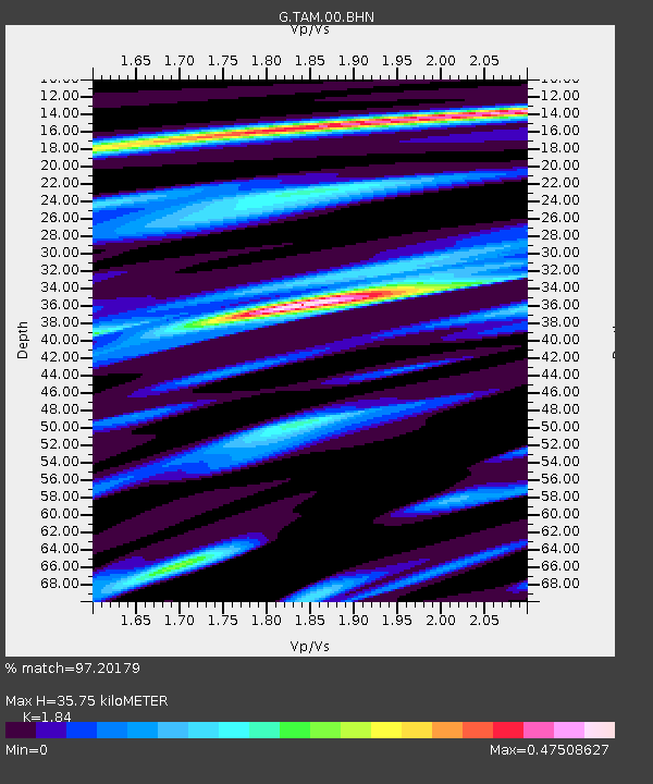
| Estimated Moho Depth: |
35.75 km |
| Estimated Crust Vp/Vs: |
1.84 |
| Assumed Crust Vp: |
6.61 km/s |
| Estimated Crust Vs: |
3.592 km/s |
| Estimated Crust Poisson's Ratio: |
0.29 |
|
| Radial Match: |
97.20179 % |
| Radial Bump: |
196 |
| Transverse Match: |
92.59646 % |
| Transverse Bump: |
400 |
| SOD ConfigId: |
626651 |
| Insert Time: |
2014-04-29 04:24:02.201 +0000 |
| GWidth: |
2.5 |
| Max Bumps: |
400 |
| Tol: |
0.001 |
|
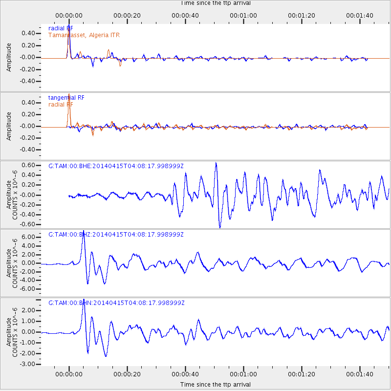
Signal To Noise
| Channel | StoN | STA | LTA |
| G:TAM:00:BHZ:20140415T04:08:17.998999Z | 20.038303 | 1.8739339E-6 | 9.351759E-8 |
| G:TAM:00:BHN:20140415T04:08:17.998999Z | 19.171963 | 6.920841E-7 | 3.6098758E-8 |
| G:TAM:00:BHE:20140415T04:08:17.998999Z | 1.1272401 | 4.0758497E-8 | 3.615778E-8 |
| Arrivals |
| Ps | 4.7 SECOND |
| PpPs | 15 SECOND |
| PsPs/PpSs | 20 SECOND |


