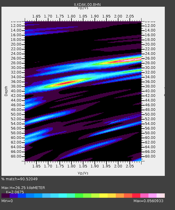
KDAK Kodiak Island, Alaska, USA - Earthquake Result Viewer
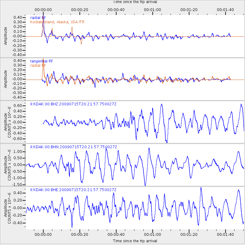
Earthquake location: New Ireland Region, P.N.G.
Earthquake latitude/longitude: -3.4/150.5
Earthquake time(UTC): 2009/07/15 (196) 20:10:42 GMT
Earthquake Depth: 13 km
Earthquake Magnitude: 5.6 MB, 6.1 MS, 6.1 MW, 6.1 MW
Earthquake Catalog/Contributor: WHDF/NEIC
Network: II Global Seismograph Network (GSN - IRIS/IDA)
Station: KDAK Kodiak Island, Alaska, USA
Lat/Lon: 57.78 N/152.58 W
Elevation: 152 m
Distance: 76.0 deg
Az: 27.557 deg
Baz: 239.557 deg
Ray Param: 0.05130915
Estimated Moho Depth: 26.25 km
Estimated Crust Vp/Vs: 2.07
Assumed Crust Vp: 6.134 km/s
Estimated Crust Vs: 2.967 km/s
Estimated Crust Poisson's Ratio: 0.35
Radial Match: 90.52049 %
Radial Bump: 387
Transverse Match: 84.981384 %
Transverse Bump: 400
SOD ConfigId: 2622
Insert Time: 2010-03-01 21:05:35.388 +0000
GWidth: 2.5
Max Bumps: 400
Tol: 0.001

Signal To Noise

ChannelStoNSTALTA
II:KDAK:00:BHN:20090715T20:21:57.750027Z2.57548022.1934426E-78.5166356E-8
II:KDAK:00:BHE:20090715T20:21:57.750027Z1.16285917.830248E-86.733617E-8
II:KDAK:00:BHZ:20090715T20:21:57.750027Z1.63659131.1019406E-76.733144E-8
Arrivals
Ps4.7 SECOND
PpPs13 SECOND
PsPs/PpSs17 SECOND