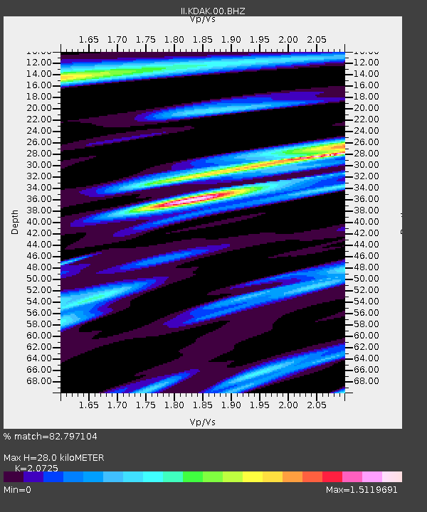
KDAK Kodiak Island, Alaska, USA - Earthquake Result Viewer

Earthquake location: Southwestern Ryukyu Isl., Japan
Earthquake latitude/longitude: 23.4/123.5
Earthquake time(UTC): 2009/08/17 (229) 10:10:55 GMT
Earthquake Depth: 10 km
Earthquake Magnitude: 5.9 MB, 6.2 MS, 6.1 MW, 6.1 MW
Earthquake Catalog/Contributor: WHDF/NEIC
Network: II Global Seismograph Network (GSN - IRIS/IDA)
Station: KDAK Kodiak Island, Alaska, USA
Lat/Lon: 57.78 N/152.58 W
Elevation: 152 m
Distance: 67.3 deg
Az: 35.271 deg
Baz: 278.05 deg
Ray Param: 0.05705719
Estimated Moho Depth: 28.0 km
Estimated Crust Vp/Vs: 2.07
Assumed Crust Vp: 6.134 km/s
Estimated Crust Vs: 2.96 km/s
Estimated Crust Poisson's Ratio: 0.35
Radial Match: 82.797104 %
Radial Bump: 400
Transverse Match: 76.39493 %
Transverse Bump: 400
SOD ConfigId: 2622
Insert Time: 2010-03-01 21:05:54.801 +0000
GWidth: 2.5
Max Bumps: 400
Tol: 0.001

Signal To Noise

ChannelStoNSTALTA
II:KDAK:00:BHZ:20090817T10:21:19.25002Z5.88889071.2376746E-62.101711E-7
II:KDAK:00:BHN:20090817T10:21:19.25002Z0.960226541.5122967E-71.5749374E-7
II:KDAK:00:BHE:20090817T10:21:19.25002Z1.50723615.3659267E-73.5601104E-7
Arrivals
Ps5.0 SECOND
PpPs14 SECOND
PsPs/PpSs19 SECOND