You are here: Home > Network List > TA - USArray Transportable Network (new EarthScope stations) Stations List
> Station R11A Troy Canyon, Currant, NV, USA > Earthquake Result Viewer
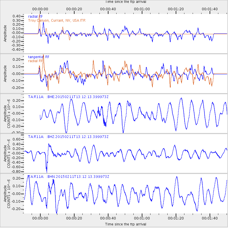
R11A Troy Canyon, Currant, NV, USA - Earthquake Result Viewer
*The percent match for this event was below the threshold and hence no stack was calculated.
| Earthquake location: |
Jujuy Province, Argentina |
| Earthquake latitude/longitude: |
-23.5/-66.7 |
| Earthquake time(UTC): |
2015/02/11 (042) 13:01:15 GMT |
| Earthquake Depth: |
201 km |
| Earthquake Magnitude: |
5.5 MWW |
| Earthquake Catalog/Contributor: |
NEIC PDE/NEIC COMCAT |
|
| Network: |
TA USArray Transportable Network (new EarthScope stations) |
| Station: |
R11A Troy Canyon, Currant, NV, USA |
| Lat/Lon: |
38.35 N/115.59 W |
| Elevation: |
1756 m |
|
| Distance: |
76.7 deg |
| Az: |
322.523 deg |
| Baz: |
134.75 deg |
| Ray Param: |
$rayparam |
*The percent match for this event was below the threshold and hence was not used in the summary stack. |
|
| Radial Match: |
39.926514 % |
| Radial Bump: |
400 |
| Transverse Match: |
44.469204 % |
| Transverse Bump: |
400 |
| SOD ConfigId: |
7019011 |
| Insert Time: |
2019-04-16 18:01:17.949 +0000 |
| GWidth: |
2.5 |
| Max Bumps: |
400 |
| Tol: |
0.001 |
|
Signal To Noise
| Channel | StoN | STA | LTA |
| TA:R11A: :BHZ:20150211T13:12:13.399973Z | 2.6700282 | 2.5890174E-7 | 9.696591E-8 |
| TA:R11A: :BHN:20150211T13:12:13.399973Z | 0.71606976 | 8.5045144E-8 | 1.1876656E-7 |
| TA:R11A: :BHE:20150211T13:12:13.399973Z | 0.42985597 | 5.078288E-8 | 1.181393E-7 |
| Arrivals |
| Ps | |
| PpPs | |
| PsPs/PpSs | |


