You are here: Home > Network List > TA - USArray Transportable Network (new EarthScope stations) Stations List
> Station W56A Indian Trail, NC, USA > Earthquake Result Viewer
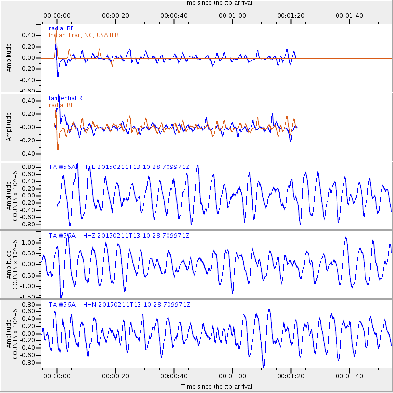
W56A Indian Trail, NC, USA - Earthquake Result Viewer
*The percent match for this event was below the threshold and hence no stack was calculated.
| Earthquake location: |
Jujuy Province, Argentina |
| Earthquake latitude/longitude: |
-23.5/-66.7 |
| Earthquake time(UTC): |
2015/02/11 (042) 13:01:15 GMT |
| Earthquake Depth: |
201 km |
| Earthquake Magnitude: |
5.5 MWW |
| Earthquake Catalog/Contributor: |
NEIC PDE/NEIC COMCAT |
|
| Network: |
TA USArray Transportable Network (new EarthScope stations) |
| Station: |
W56A Indian Trail, NC, USA |
| Lat/Lon: |
35.13 N/80.58 W |
| Elevation: |
177 m |
|
| Distance: |
59.8 deg |
| Az: |
346.864 deg |
| Baz: |
165.257 deg |
| Ray Param: |
$rayparam |
*The percent match for this event was below the threshold and hence was not used in the summary stack. |
|
| Radial Match: |
57.253773 % |
| Radial Bump: |
400 |
| Transverse Match: |
82.13467 % |
| Transverse Bump: |
387 |
| SOD ConfigId: |
7019011 |
| Insert Time: |
2019-04-16 18:01:27.370 +0000 |
| GWidth: |
2.5 |
| Max Bumps: |
400 |
| Tol: |
0.001 |
|
Signal To Noise
| Channel | StoN | STA | LTA |
| TA:W56A: :HHZ:20150211T13:10:28.709971Z | 1.6820337 | 8.994617E-7 | 5.3474656E-7 |
| TA:W56A: :HHN:20150211T13:10:28.709971Z | 1.8102415 | 3.6445078E-7 | 2.0132717E-7 |
| TA:W56A: :HHE:20150211T13:10:28.709971Z | 0.9202237 | 3.524158E-7 | 3.8296753E-7 |
| Arrivals |
| Ps | |
| PpPs | |
| PsPs/PpSs | |


