You are here: Home > Network List > II - Global Seismograph Network (GSN - IRIS/IDA) Stations List
> Station KDAK Kodiak Island, Alaska, USA > Earthquake Result Viewer
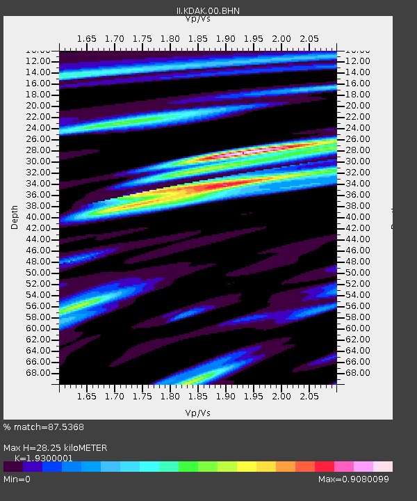
KDAK Kodiak Island, Alaska, USA - Earthquake Result Viewer
| Earthquake location: |
Mindanao, Philippines |
| Earthquake latitude/longitude: |
7.9/126.9 |
| Earthquake time(UTC): |
2009/05/21 (141) 05:53:53 GMT |
| Earthquake Depth: |
14 km |
| Earthquake Magnitude: |
5.5 MB, 5.3 MS, 5.7 MW, 5.7 MW |
| Earthquake Catalog/Contributor: |
WHDF/NEIC |
|
| Network: |
II Global Seismograph Network (GSN - IRIS/IDA) |
| Station: |
KDAK Kodiak Island, Alaska, USA |
| Lat/Lon: |
57.78 N/152.58 W |
| Elevation: |
152 m |
|
| Distance: |
78.3 deg |
| Az: |
32.654 deg |
| Baz: |
266.21 deg |
| Ray Param: |
0.049722183 |
| Estimated Moho Depth: |
28.25 km |
| Estimated Crust Vp/Vs: |
1.93 |
| Assumed Crust Vp: |
6.134 km/s |
| Estimated Crust Vs: |
3.178 km/s |
| Estimated Crust Poisson's Ratio: |
0.32 |
|
| Radial Match: |
87.5368 % |
| Radial Bump: |
400 |
| Transverse Match: |
66.97409 % |
| Transverse Bump: |
400 |
| SOD ConfigId: |
2648 |
| Insert Time: |
2010-03-01 21:06:17.958 +0000 |
| GWidth: |
2.5 |
| Max Bumps: |
400 |
| Tol: |
0.001 |
|

Signal To Noise
| Channel | StoN | STA | LTA |
| II:KDAK:00:BHN:20090521T06:05:21.898997Z | 6.463343 | 4.8885204E-7 | 7.563455E-8 |
| II:KDAK:00:BHE:20090521T06:05:21.898997Z | 1.5792998 | 1.0496161E-7 | 6.646085E-8 |
| II:KDAK:00:BHZ:20090521T06:05:21.898997Z | 2.5584636 | 1.6748437E-7 | 6.546287E-8 |
| Arrivals |
| Ps | 4.4 SECOND |
| PpPs | 13 SECOND |
| PsPs/PpSs | 18 SECOND |


