You are here: Home > Network List > II - Global Seismograph Network (GSN - IRIS/IDA) Stations List
> Station KDAK Kodiak Island, Alaska, USA > Earthquake Result Viewer
KDAK Kodiak Island, Alaska, USA - Earthquake Result Viewer
| Earthquake location: |
Seram, Indonesia |
| Earthquake latitude/longitude: |
-3.9/127.5 |
| Earthquake time(UTC): |
2009/05/29 (149) 00:58:36 GMT |
| Earthquake Depth: |
41 km |
| Earthquake Magnitude: |
5.8 MB, 5.5 MW |
| Earthquake Catalog/Contributor: |
WHDF/NEIC |
|
| Network: |
II Global Seismograph Network (GSN - IRIS/IDA) |
| Station: |
KDAK Kodiak Island, Alaska, USA |
| Lat/Lon: |
57.78 N/152.58 W |
| Elevation: |
152 m |
|
| Distance: |
87.9 deg |
| Az: |
31.859 deg |
| Baz: |
259.44 deg |
| Ray Param: |
0.042897854 |
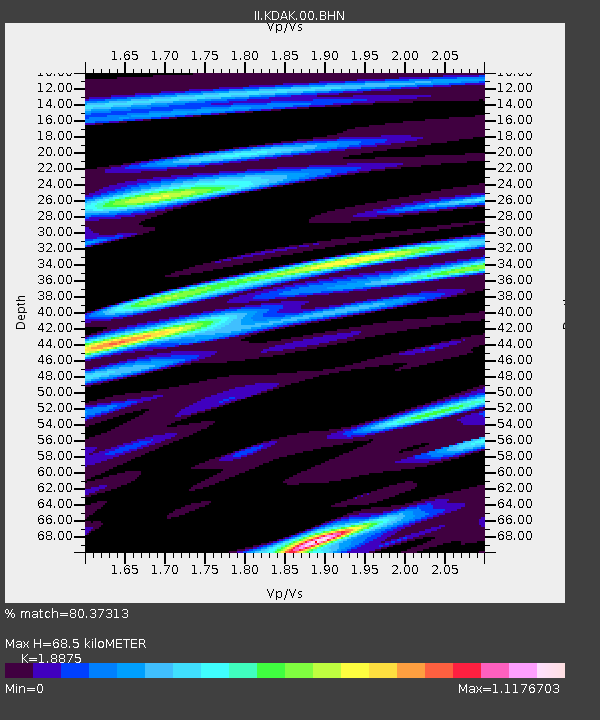
| Estimated Moho Depth: |
68.5 km |
| Estimated Crust Vp/Vs: |
1.89 |
| Assumed Crust Vp: |
6.134 km/s |
| Estimated Crust Vs: |
3.25 km/s |
| Estimated Crust Poisson's Ratio: |
0.30 |
|
| Radial Match: |
80.37313 % |
| Radial Bump: |
400 |
| Transverse Match: |
75.411095 % |
| Transverse Bump: |
400 |
| SOD ConfigId: |
2648 |
| Insert Time: |
2010-03-01 21:06:22.743 +0000 |
| GWidth: |
2.5 |
| Max Bumps: |
400 |
| Tol: |
0.001 |
|

Signal To Noise
| Channel | StoN | STA | LTA |
| II:KDAK:00:BHN:20090529T01:10:50.700027Z | 5.387093 | 5.7822393E-7 | 1.07335055E-7 |
| II:KDAK:00:BHE:20090529T01:10:50.700027Z | 2.628415 | 1.8217244E-7 | 6.9308854E-8 |
| II:KDAK:00:BHZ:20090529T01:10:50.700027Z | 1.8980743 | 1.7262317E-7 | 9.0946486E-8 |
| Arrivals |
| Ps | 10 SECOND |
| PpPs | 32 SECOND |
| PsPs/PpSs | 42 SECOND |


