You are here: Home > Network List > TA - USArray Transportable Network (new EarthScope stations) Stations List
> Station G59A Clarenceville, QC, USA > Earthquake Result Viewer
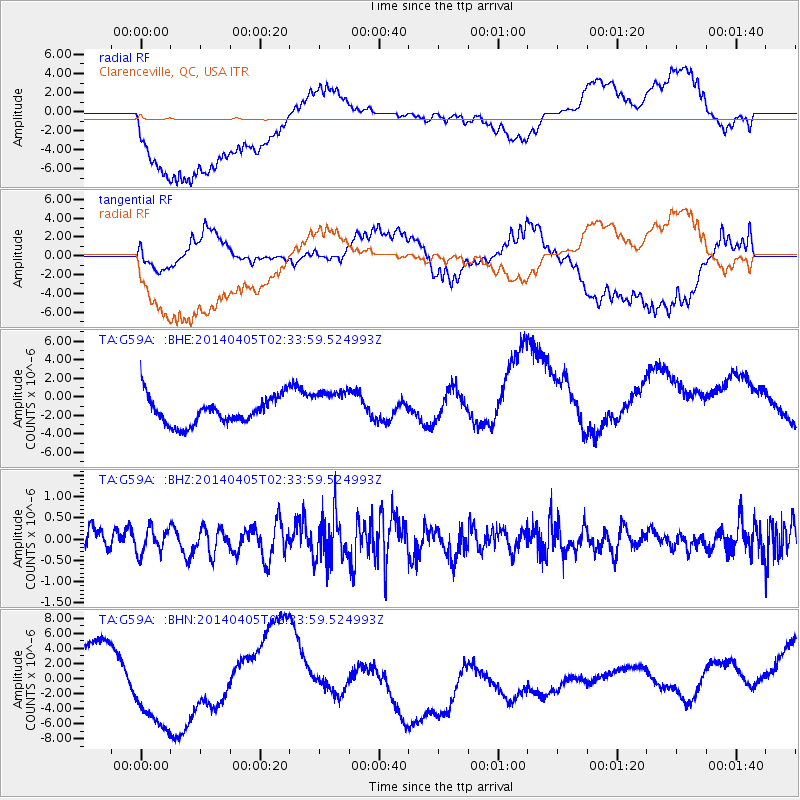
G59A Clarenceville, QC, USA - Earthquake Result Viewer
*The percent match for this event was below the threshold and hence no stack was calculated.
| Earthquake location: |
Near Coast Of Central Chile |
| Earthquake latitude/longitude: |
-32.8/-71.6 |
| Earthquake time(UTC): |
2014/04/05 (095) 02:22:38 GMT |
| Earthquake Depth: |
40 km |
| Earthquake Magnitude: |
5.6 MWC, 5.6 MWC |
| Earthquake Catalog/Contributor: |
NEIC PDE/NEIC COMCAT |
|
| Network: |
TA USArray Transportable Network (new EarthScope stations) |
| Station: |
G59A Clarenceville, QC, USA |
| Lat/Lon: |
45.08 N/73.18 W |
| Elevation: |
36 m |
|
| Distance: |
77.5 deg |
| Az: |
358.839 deg |
| Baz: |
178.619 deg |
| Ray Param: |
$rayparam |
*The percent match for this event was below the threshold and hence was not used in the summary stack. |
|
| Radial Match: |
57.194046 % |
| Radial Bump: |
400 |
| Transverse Match: |
46.07475 % |
| Transverse Bump: |
400 |
| SOD ConfigId: |
626651 |
| Insert Time: |
2014-05-02 00:30:32.295 +0000 |
| GWidth: |
2.5 |
| Max Bumps: |
400 |
| Tol: |
0.001 |
|
Signal To Noise
| Channel | StoN | STA | LTA |
| TA:G59A: :BHZ:20140405T02:33:59.524993Z | 1.0026591 | 2.9428082E-7 | 2.9350036E-7 |
| TA:G59A: :BHN:20140405T02:33:59.524993Z | 2.8871083 | 9.429815E-6 | 3.2661799E-6 |
| TA:G59A: :BHE:20140405T02:33:59.524993Z | 1.4220785 | 2.043802E-6 | 1.4371935E-6 |
| Arrivals |
| Ps | |
| PpPs | |
| PsPs/PpSs | |


