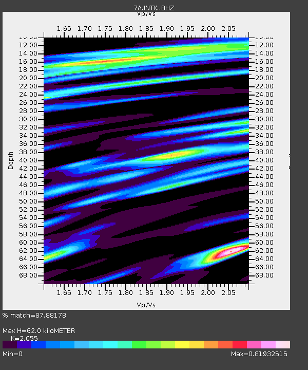
INTX Elkton, Virginia USA - Earthquake Result Viewer

Earthquake location: Jujuy Province, Argentina
Earthquake latitude/longitude: -23.1/-66.7
Earthquake time(UTC): 2015/02/11 (042) 18:57:22 GMT
Earthquake Depth: 223 km
Earthquake Magnitude: 6.7 MWW, 6.7 MWC, 6.7 MWB, 6.9 MI
Earthquake Catalog/Contributor: NEIC PDE/NEIC COMCAT
Network: 7A Mid-Atlantic Geophysical Integrative Collaboration
Station: INTX Elkton, Virginia USA
Lat/Lon: 38.40 N/78.59 W
Elevation: 320 m
Distance: 62.2 deg
Az: 349.451 deg
Baz: 167.611 deg
Ray Param: 0.05968511
Estimated Moho Depth: 62.0 km
Estimated Crust Vp/Vs: 2.06
Assumed Crust Vp: 6.159 km/s
Estimated Crust Vs: 2.997 km/s
Estimated Crust Poisson's Ratio: 0.34
Radial Match: 87.88178 %
Radial Bump: 400
Transverse Match: 55.637657 %
Transverse Bump: 400
SOD ConfigId: 7019011
Insert Time: 2019-04-16 18:06:31.004 +0000
GWidth: 2.5
Max Bumps: 400
Tol: 0.001

Signal To Noise

ChannelStoNSTALTA
7A:INTX: :BHZ:20150211T19:06:49.214995Z14.5716973.9827178E-62.7331873E-7
7A:INTX: :BHN:20150211T19:06:49.214995Z4.4312032.6491819E-65.9784713E-7
7A:INTX: :BHE:20150211T19:06:49.214995Z2.52518561.0463496E-64.1436542E-7
Arrivals
Ps11 SECOND
PpPs30 SECOND
PsPs/PpSs41 SECOND