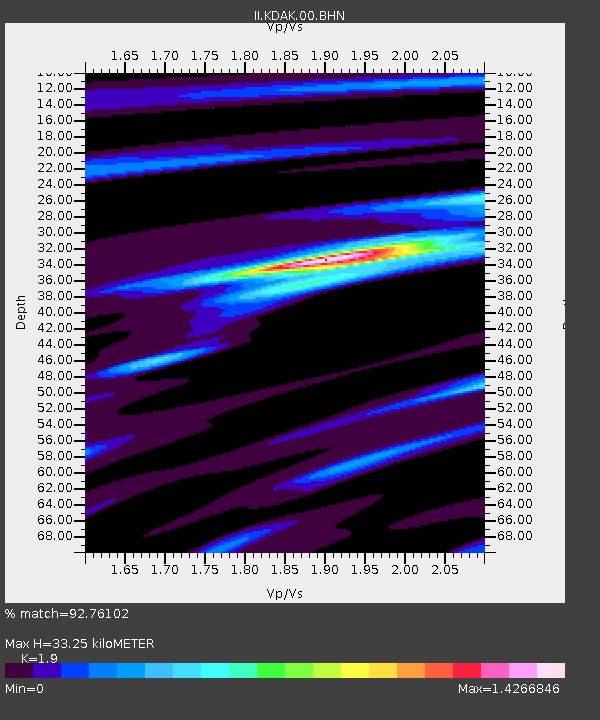
KDAK Kodiak Island, Alaska, USA - Earthquake Result Viewer

Earthquake location: Irian Jaya Region, Indonesia
Earthquake latitude/longitude: -0.7/133.3
Earthquake time(UTC): 2009/01/03 (003) 22:33:40 GMT
Earthquake Depth: 23 km
Earthquake Magnitude: 6.7 MB, 7.4 MS, 7.4 MW, 7.3 MW
Earthquake Catalog/Contributor: WHDF/NEIC
Network: II Global Seismograph Network (GSN - IRIS/IDA)
Station: KDAK Kodiak Island, Alaska, USA
Lat/Lon: 57.78 N/152.58 W
Elevation: 152 m
Distance: 82.2 deg
Az: 31.339 deg
Baz: 256.124 deg
Ray Param: 0.04706102
Estimated Moho Depth: 33.25 km
Estimated Crust Vp/Vs: 1.90
Assumed Crust Vp: 6.134 km/s
Estimated Crust Vs: 3.228 km/s
Estimated Crust Poisson's Ratio: 0.31
Radial Match: 92.76102 %
Radial Bump: 400
Transverse Match: 71.35757 %
Transverse Bump: 400
SOD ConfigId: 2658
Insert Time: 2010-03-01 21:06:41.314 +0000
GWidth: 2.5
Max Bumps: 400
Tol: 0.001

Signal To Noise

ChannelStoNSTALTA
II:KDAK:00:BHN:20090103T22:45:27.80001Z2.77569414.358533E-61.5702497E-6
II:KDAK:00:BHE:20090103T22:45:27.80001Z0.71767887.907558E-71.1018241E-6
II:KDAK:00:BHZ:20090103T22:45:27.80001Z1.18394041.3345006E-61.1271686E-6
Arrivals
Ps5.0 SECOND
PpPs15 SECOND
PsPs/PpSs20 SECOND