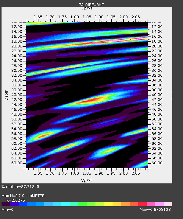
WIRE Hazelwood, West Virginia USA - Earthquake Result Viewer

Earthquake location: Jujuy Province, Argentina
Earthquake latitude/longitude: -23.1/-66.7
Earthquake time(UTC): 2015/02/11 (042) 18:57:22 GMT
Earthquake Depth: 223 km
Earthquake Magnitude: 6.7 MWW, 6.7 MWC, 6.7 MWB, 6.9 MI
Earthquake Catalog/Contributor: NEIC PDE/NEIC COMCAT
Network: 7A Mid-Atlantic Geophysical Integrative Collaboration
Station: WIRE Hazelwood, West Virginia USA
Lat/Lon: 38.85 N/79.84 W
Elevation: 613 m
Distance: 62.9 deg
Az: 348.489 deg
Baz: 166.39 deg
Ray Param: 0.059262164
Estimated Moho Depth: 17.0 km
Estimated Crust Vp/Vs: 2.03
Assumed Crust Vp: 6.159 km/s
Estimated Crust Vs: 3.038 km/s
Estimated Crust Poisson's Ratio: 0.34
Radial Match: 87.71345 %
Radial Bump: 400
Transverse Match: 74.289536 %
Transverse Bump: 400
SOD ConfigId: 7019011
Insert Time: 2019-04-16 18:06:43.636 +0000
GWidth: 2.5
Max Bumps: 400
Tol: 0.001

Signal To Noise

ChannelStoNSTALTA
7A:WIRE: :BHZ:20150211T19:06:53.560027Z10.9685084.823094E-64.39722E-7
7A:WIRE: :BHN:20150211T19:06:53.560027Z3.81120562.0664452E-65.422025E-7
7A:WIRE: :BHE:20150211T19:06:53.560027Z1.68411425.6983197E-73.383571E-7
Arrivals
Ps2.9 SECOND
PpPs8.1 SECOND
PsPs/PpSs11 SECOND