You are here: Home > Network List > II - Global Seismograph Network (GSN - IRIS/IDA) Stations List
> Station KDAK Kodiak Island, Alaska, USA > Earthquake Result Viewer
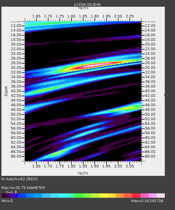
KDAK Kodiak Island, Alaska, USA - Earthquake Result Viewer
| Earthquake location: |
Kermadec Islands Region |
| Earthquake latitude/longitude: |
-31.8/-179.3 |
| Earthquake time(UTC): |
2006/05/16 (136) 10:39:23 GMT |
| Earthquake Depth: |
152 km |
| Earthquake Magnitude: |
6.8 MB, 7.4 MW, 7.4 MW |
| Earthquake Catalog/Contributor: |
WHDF/NEIC |
|
| Network: |
II Global Seismograph Network (GSN - IRIS/IDA) |
| Station: |
KDAK Kodiak Island, Alaska, USA |
| Lat/Lon: |
57.78 N/152.58 W |
| Elevation: |
152 m |
|
| Distance: |
92.0 deg |
| Az: |
13.951 deg |
| Baz: |
202.538 deg |
| Ray Param: |
0.04145537 |
| Estimated Moho Depth: |
28.75 km |
| Estimated Crust Vp/Vs: |
1.90 |
| Assumed Crust Vp: |
6.134 km/s |
| Estimated Crust Vs: |
3.228 km/s |
| Estimated Crust Poisson's Ratio: |
0.31 |
|
| Radial Match: |
92.29833 % |
| Radial Bump: |
400 |
| Transverse Match: |
82.592636 % |
| Transverse Bump: |
400 |
| SOD ConfigId: |
2669 |
| Insert Time: |
2010-03-01 21:06:52.432 +0000 |
| GWidth: |
2.5 |
| Max Bumps: |
400 |
| Tol: |
0.001 |
|

Signal To Noise
| Channel | StoN | STA | LTA |
| II:KDAK:00:BHN:20060516T10:51:43.699009Z | 3.5471618 | 5.9944364E-7 | 1.6899247E-7 |
| II:KDAK:00:BHE:20060516T10:51:43.699009Z | 1.3751609 | 2.2758643E-7 | 1.6549802E-7 |
| II:KDAK:00:BHZ:20060516T10:51:43.699009Z | 11.006698 | 2.0571797E-6 | 1.8690254E-7 |
| Arrivals |
| Ps | 4.3 SECOND |
| PpPs | 13 SECOND |
| PsPs/PpSs | 18 SECOND |


