You are here: Home > Network List > II - Global Seismograph Network (GSN - IRIS/IDA) Stations List
> Station KDAK Kodiak Island, Alaska, USA > Earthquake Result Viewer
KDAK Kodiak Island, Alaska, USA - Earthquake Result Viewer
| Earthquake location: |
Southern Greece |
| Earthquake latitude/longitude: |
36.3/23.2 |
| Earthquake time(UTC): |
2006/01/08 (008) 11:34:55 GMT |
| Earthquake Depth: |
66 km |
| Earthquake Magnitude: |
6.5 MB, 6.7 MW, 6.7 MW |
| Earthquake Catalog/Contributor: |
WHDF/NEIC |
|
| Network: |
II Global Seismograph Network (GSN - IRIS/IDA) |
| Station: |
KDAK Kodiak Island, Alaska, USA |
| Lat/Lon: |
57.78 N/152.58 W |
| Elevation: |
152 m |
|
| Distance: |
86.2 deg |
| Az: |
357.744 deg |
| Baz: |
3.402 deg |
| Ray Param: |
0.0441011 |
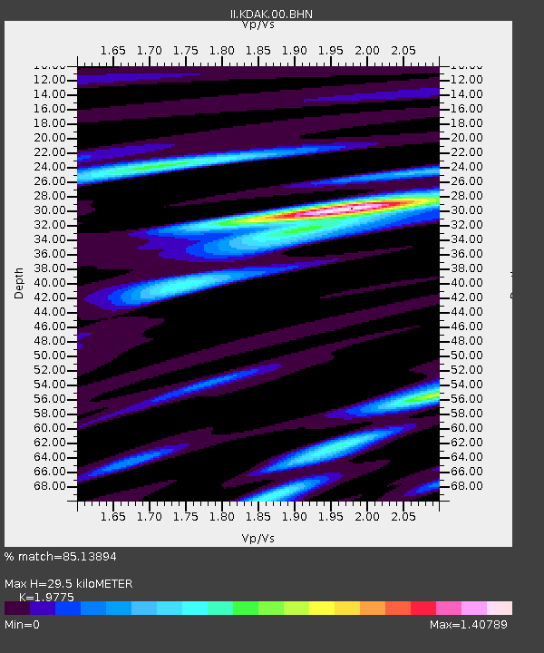
| Estimated Moho Depth: |
29.5 km |
| Estimated Crust Vp/Vs: |
1.98 |
| Assumed Crust Vp: |
6.134 km/s |
| Estimated Crust Vs: |
3.102 km/s |
| Estimated Crust Poisson's Ratio: |
0.33 |
|
| Radial Match: |
85.13894 % |
| Radial Bump: |
400 |
| Transverse Match: |
89.041466 % |
| Transverse Bump: |
400 |
| SOD ConfigId: |
4977 |
| Insert Time: |
2010-03-01 21:07:23.226 +0000 |
| GWidth: |
2.5 |
| Max Bumps: |
400 |
| Tol: |
0.001 |
|

Signal To Noise
| Channel | StoN | STA | LTA |
| II:KDAK:00:BHN:20060108T11:46:58.65001Z | 1.602838 | 1.185318E-6 | 7.39512E-7 |
| II:KDAK:00:BHE:20060108T11:46:58.65001Z | 1.1803648 | 6.683813E-7 | 5.6624975E-7 |
| II:KDAK:00:BHZ:20060108T11:46:58.65001Z | 5.194189 | 3.1842073E-6 | 6.130326E-7 |
| Arrivals |
| Ps | 4.8 SECOND |
| PpPs | 14 SECOND |
| PsPs/PpSs | 19 SECOND |


