You are here: Home > Network List > TA - USArray Transportable Network (new EarthScope stations) Stations List
> Station J01E Myrtle Point, OR, USA > Earthquake Result Viewer
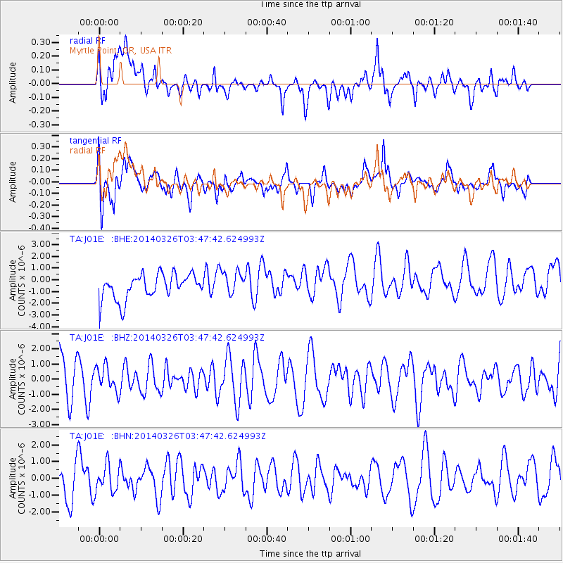
J01E Myrtle Point, OR, USA - Earthquake Result Viewer
*The percent match for this event was below the threshold and hence no stack was calculated.
| Earthquake location: |
South Of Fiji Islands |
| Earthquake latitude/longitude: |
-26.1/179.3 |
| Earthquake time(UTC): |
2014/03/26 (085) 03:36:25 GMT |
| Earthquake Depth: |
510 km |
| Earthquake Magnitude: |
6.1 MB |
| Earthquake Catalog/Contributor: |
NEIC PDE/NEIC COMCAT |
|
| Network: |
TA USArray Transportable Network (new EarthScope stations) |
| Station: |
J01E Myrtle Point, OR, USA |
| Lat/Lon: |
43.16 N/123.93 W |
| Elevation: |
128 m |
|
| Distance: |
86.4 deg |
| Az: |
37.814 deg |
| Baz: |
228.874 deg |
| Ray Param: |
$rayparam |
*The percent match for this event was below the threshold and hence was not used in the summary stack. |
|
| Radial Match: |
47.4476 % |
| Radial Bump: |
400 |
| Transverse Match: |
53.883953 % |
| Transverse Bump: |
400 |
| SOD ConfigId: |
626651 |
| Insert Time: |
2014-05-02 02:41:10.443 +0000 |
| GWidth: |
2.5 |
| Max Bumps: |
400 |
| Tol: |
0.001 |
|
Signal To Noise
| Channel | StoN | STA | LTA |
| TA:J01E: :BHZ:20140326T03:47:42.624993Z | 0.6069544 | 8.190368E-7 | 1.3494207E-6 |
| TA:J01E: :BHN:20140326T03:47:42.624993Z | 0.77229804 | 7.967664E-7 | 1.0316826E-6 |
| TA:J01E: :BHE:20140326T03:47:42.624993Z | 0.93415004 | 9.928773E-7 | 1.062867E-6 |
| Arrivals |
| Ps | |
| PpPs | |
| PsPs/PpSs | |


