GMR Granite Mountains Research Center - Earthquake Result Viewer
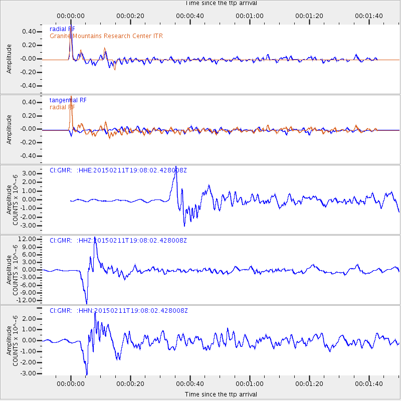
Earthquake location: Jujuy Province, Argentina
Earthquake latitude/longitude: -23.1/-66.7
Earthquake time(UTC): 2015/02/11 (042) 18:57:22 GMT
Earthquake Depth: 223 km
Earthquake Magnitude: 6.7 MWW, 6.7 MWC, 6.7 MWB, 6.9 MI
Earthquake Catalog/Contributor: NEIC PDE/NEIC COMCAT
Network: CI Caltech Regional Seismic Network
Station: GMR Granite Mountains Research Center
Lat/Lon: 34.78 N/115.66 W
Elevation: 1326 m
Distance: 74.0 deg
Az: 319.761 deg
Baz: 133.731 deg
Ray Param: 0.05203061
Estimated Moho Depth: 27.0 km
Estimated Crust Vp/Vs: 1.80
Assumed Crust Vp: 6.276 km/s
Estimated Crust Vs: 3.491 km/s
Estimated Crust Poisson's Ratio: 0.28
Radial Match: 94.95782 %
Radial Bump: 400
Transverse Match: 86.60332 %
Transverse Bump: 400
SOD ConfigId: 7019011
Insert Time: 2019-04-16 18:08:09.263 +0000
GWidth: 2.5
Max Bumps: 400
Tol: 0.001

Signal To Noise

ChannelStoNSTALTA
CI:GMR: :HHZ:20150211T19:08:02.428008Z20.5945013.1982272E-61.552952E-7
CI:GMR: :HHN:20150211T19:08:02.428008Z5.61516057.2006054E-71.2823509E-7
CI:GMR: :HHE:20150211T19:08:02.428008Z11.0672269.489383E-78.57431E-8
Arrivals
Ps3.5 SECOND
PpPs12 SECOND
PsPs/PpSs15 SECOND