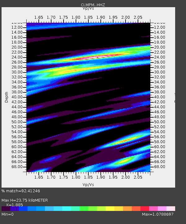
MPM Manuel Prospect Mine, California, USA - Earthquake Result Viewer
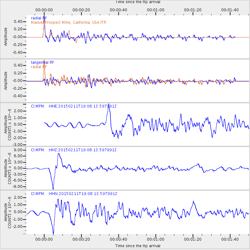
Earthquake location: Jujuy Province, Argentina
Earthquake latitude/longitude: -23.1/-66.7
Earthquake time(UTC): 2015/02/11 (042) 18:57:22 GMT
Earthquake Depth: 223 km
Earthquake Magnitude: 6.7 MWW, 6.7 MWC, 6.7 MWB, 6.9 MI
Earthquake Catalog/Contributor: NEIC PDE/NEIC COMCAT
Network: CI Caltech Regional Seismic Network
Station: MPM Manuel Prospect Mine, California, USA
Lat/Lon: 36.06 N/117.49 W
Elevation: 185 m
Distance: 75.9 deg
Az: 319.662 deg
Baz: 132.649 deg
Ray Param: 0.050737604
Estimated Moho Depth: 23.75 km
Estimated Crust Vp/Vs: 1.88
Assumed Crust Vp: 6.279 km/s
Estimated Crust Vs: 3.331 km/s
Estimated Crust Poisson's Ratio: 0.30
Radial Match: 92.41246 %
Radial Bump: 400
Transverse Match: 79.48775 %
Transverse Bump: 400
SOD ConfigId: 7019011
Insert Time: 2019-04-16 18:08:20.135 +0000
GWidth: 2.5
Max Bumps: 400
Tol: 0.001

Signal To Noise

ChannelStoNSTALTA
CI:MPM: :HHZ:20150211T19:08:13.597991Z30.0404833.4819427E-61.1590835E-7
CI:MPM: :HHN:20150211T19:08:13.597991Z6.97184049.430172E-71.3526088E-7
CI:MPM: :HHE:20150211T19:08:13.597991Z4.3732141.0395289E-62.3770366E-7
Arrivals
Ps3.4 SECOND
PpPs11 SECOND
PsPs/PpSs14 SECOND