You are here: Home > Network List > II - Global Seismograph Network (GSN - IRIS/IDA) Stations List
> Station KDAK Kodiak Island, Alaska, USA > Earthquake Result Viewer
KDAK Kodiak Island, Alaska, USA - Earthquake Result Viewer
| Earthquake location: |
Banda Sea |
| Earthquake latitude/longitude: |
-4.1/127.4 |
| Earthquake time(UTC): |
2000/08/28 (241) 15:05:47 GMT |
| Earthquake Depth: |
16 km |
| Earthquake Magnitude: |
6.5 MB, 6.8 MS, 6.8 MW, 6.7 ME |
| Earthquake Catalog/Contributor: |
WHDF/NEIC |
|
| Network: |
II Global Seismograph Network (GSN - IRIS/IDA) |
| Station: |
KDAK Kodiak Island, Alaska, USA |
| Lat/Lon: |
57.78 N/152.58 W |
| Elevation: |
152 m |
|
| Distance: |
88.1 deg |
| Az: |
31.862 deg |
| Baz: |
259.387 deg |
| Ray Param: |
0.04279802 |
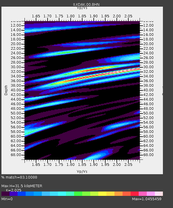
| Estimated Moho Depth: |
31.5 km |
| Estimated Crust Vp/Vs: |
2.03 |
| Assumed Crust Vp: |
6.134 km/s |
| Estimated Crust Vs: |
3.029 km/s |
| Estimated Crust Poisson's Ratio: |
0.34 |
|
| Radial Match: |
83.10088 % |
| Radial Bump: |
400 |
| Transverse Match: |
74.295265 % |
| Transverse Bump: |
400 |
| SOD ConfigId: |
3744 |
| Insert Time: |
2010-03-01 21:07:40.220 +0000 |
| GWidth: |
2.5 |
| Max Bumps: |
400 |
| Tol: |
0.001 |
|

Signal To Noise
| Channel | StoN | STA | LTA |
| II:KDAK:00:BHN:20000828T15:18:06.277004Z | 0.84144586 | 4.1601348E-7 | 4.9440314E-7 |
| II:KDAK:00:BHE:20000828T15:18:06.277004Z | 1.9754292 | 7.979569E-7 | 4.0394102E-7 |
| II:KDAK:00:BHZ:20000828T15:18:06.277004Z | 4.757056 | 2.72622E-6 | 5.730897E-7 |
| Arrivals |
| Ps | 5.4 SECOND |
| PpPs | 15 SECOND |
| PsPs/PpSs | 21 SECOND |


