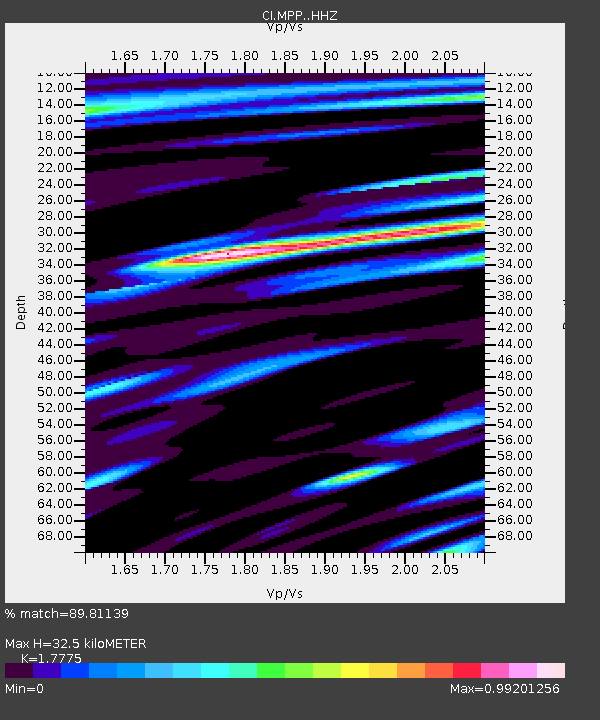
MPP McPhearson Peak - Earthquake Result Viewer
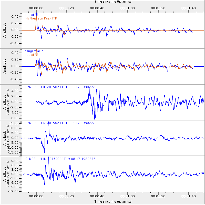
Earthquake location: Jujuy Province, Argentina
Earthquake latitude/longitude: -23.1/-66.7
Earthquake time(UTC): 2015/02/11 (042) 18:57:22 GMT
Earthquake Depth: 223 km
Earthquake Magnitude: 6.7 MWW, 6.7 MWC, 6.7 MWB, 6.9 MI
Earthquake Catalog/Contributor: NEIC PDE/NEIC COMCAT
Network: CI Caltech Regional Seismic Network
Station: MPP McPhearson Peak
Lat/Lon: 34.89 N/119.81 W
Elevation: 1739 m
Distance: 76.6 deg
Az: 317.465 deg
Baz: 130.785 deg
Ray Param: 0.05031368
Estimated Moho Depth: 32.5 km
Estimated Crust Vp/Vs: 1.78
Assumed Crust Vp: 6.1 km/s
Estimated Crust Vs: 3.432 km/s
Estimated Crust Poisson's Ratio: 0.27
Radial Match: 89.81139 %
Radial Bump: 400
Transverse Match: 87.43878 %
Transverse Bump: 400
SOD ConfigId: 7019011
Insert Time: 2019-04-16 18:08:20.384 +0000
GWidth: 2.5
Max Bumps: 400
Tol: 0.001

Signal To Noise

ChannelStoNSTALTA
CI:MPP: :HHZ:20150211T19:08:17.198027Z16.2639663.7660127E-62.3155563E-7
CI:MPP: :HHN:20150211T19:08:17.198027Z3.6024781.1793204E-63.2736367E-7
CI:MPP: :HHE:20150211T19:08:17.198027Z3.14584781.1407111E-63.626085E-7
Arrivals
Ps4.3 SECOND
PpPs14 SECOND
PsPs/PpSs19 SECOND