You are here: Home > Network List > II - Global Seismograph Network (GSN - IRIS/IDA) Stations List
> Station KDAK Kodiak Island, Alaska, USA > Earthquake Result Viewer
KDAK Kodiak Island, Alaska, USA - Earthquake Result Viewer
| Earthquake location: |
Michoacan, Mexico |
| Earthquake latitude/longitude: |
18.2/-102.5 |
| Earthquake time(UTC): |
2000/08/09 (222) 11:41:47 GMT |
| Earthquake Depth: |
46 km |
| Earthquake Magnitude: |
6.1 MB, 6.5 MS, 6.5 MW, 6.4 MW |
| Earthquake Catalog/Contributor: |
WHDF/NEIC |
|
| Network: |
II Global Seismograph Network (GSN - IRIS/IDA) |
| Station: |
KDAK Kodiak Island, Alaska, USA |
| Lat/Lon: |
57.78 N/152.58 W |
| Elevation: |
152 m |
|
| Distance: |
53.9 deg |
| Az: |
329.44 deg |
| Baz: |
115.545 deg |
| Ray Param: |
0.06566196 |
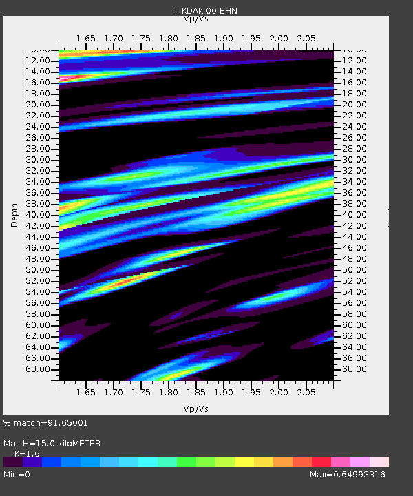
| Estimated Moho Depth: |
15.0 km |
| Estimated Crust Vp/Vs: |
1.60 |
| Assumed Crust Vp: |
6.134 km/s |
| Estimated Crust Vs: |
3.834 km/s |
| Estimated Crust Poisson's Ratio: |
0.18 |
|
| Radial Match: |
91.65001 % |
| Radial Bump: |
400 |
| Transverse Match: |
75.76287 % |
| Transverse Bump: |
400 |
| SOD ConfigId: |
3744 |
| Insert Time: |
2010-03-01 21:07:42.506 +0000 |
| GWidth: |
2.5 |
| Max Bumps: |
400 |
| Tol: |
0.001 |
|
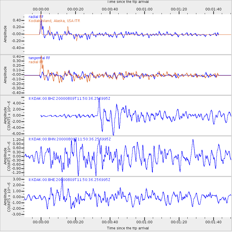
Signal To Noise
| Channel | StoN | STA | LTA |
| II:KDAK:00:BHN:20000809T11:50:36.256995Z | 2.07315 | 4.1076947E-7 | 1.9813785E-7 |
| II:KDAK:00:BHE:20000809T11:50:36.256995Z | 3.2719364 | 7.017797E-7 | 2.1448452E-7 |
| II:KDAK:00:BHZ:20000809T11:50:36.256995Z | 8.316847 | 1.947947E-6 | 2.3421701E-7 |
| Arrivals |
| Ps | 1.5 SECOND |
| PpPs | 6.0 SECOND |
| PsPs/PpSs | 7.6 SECOND |


