You are here: Home > Network List > II - Global Seismograph Network (GSN - IRIS/IDA) Stations List
> Station KDAK Kodiak Island, Alaska, USA > Earthquake Result Viewer
KDAK Kodiak Island, Alaska, USA - Earthquake Result Viewer
| Earthquake location: |
Banda Sea |
| Earthquake latitude/longitude: |
-7.0/123.4 |
| Earthquake time(UTC): |
2000/08/07 (220) 14:33:55 GMT |
| Earthquake Depth: |
648 km |
| Earthquake Magnitude: |
6.5 MB, 6.5 MW, 6.5 MW |
| Earthquake Catalog/Contributor: |
WHDF/NEIC |
|
| Network: |
II Global Seismograph Network (GSN - IRIS/IDA) |
| Station: |
KDAK Kodiak Island, Alaska, USA |
| Lat/Lon: |
57.78 N/152.58 W |
| Elevation: |
152 m |
|
| Distance: |
92.7 deg |
| Az: |
32.237 deg |
| Baz: |
261.261 deg |
| Ray Param: |
0.040833566 |
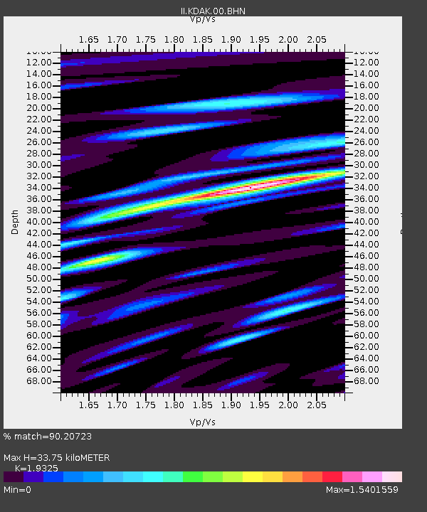
| Estimated Moho Depth: |
33.75 km |
| Estimated Crust Vp/Vs: |
1.93 |
| Assumed Crust Vp: |
6.134 km/s |
| Estimated Crust Vs: |
3.174 km/s |
| Estimated Crust Poisson's Ratio: |
0.32 |
|
| Radial Match: |
90.20723 % |
| Radial Bump: |
400 |
| Transverse Match: |
87.5367 % |
| Transverse Bump: |
400 |
| SOD ConfigId: |
3744 |
| Insert Time: |
2010-03-01 21:07:44.605 +0000 |
| GWidth: |
2.5 |
| Max Bumps: |
400 |
| Tol: |
0.001 |
|

Signal To Noise
| Channel | StoN | STA | LTA |
| II:KDAK:00:BHN:20000807T14:45:29.425015Z | 8.172743 | 4.7230483E-7 | 5.779025E-8 |
| II:KDAK:00:BHE:20000807T14:45:29.425015Z | 10.583986 | 6.6850805E-7 | 6.316221E-8 |
| II:KDAK:00:BHZ:20000807T14:45:29.425015Z | 35.428623 | 2.2934446E-6 | 6.473422E-8 |
| Arrivals |
| Ps | 5.2 SECOND |
| PpPs | 16 SECOND |
| PsPs/PpSs | 21 SECOND |


