You are here: Home > Network List > CN - Canadian National Seismograph Network Stations List
> Station A54 Misere, QC, CA > Earthquake Result Viewer
A54 Misere, QC, CA - Earthquake Result Viewer
| Earthquake location: |
Jujuy Province, Argentina |
| Earthquake latitude/longitude: |
-23.1/-66.7 |
| Earthquake time(UTC): |
2015/02/11 (042) 18:57:22 GMT |
| Earthquake Depth: |
223 km |
| Earthquake Magnitude: |
6.7 MWW, 6.7 MWC, 6.7 MWB, 6.9 MI |
| Earthquake Catalog/Contributor: |
NEIC PDE/NEIC COMCAT |
|
| Network: |
CN Canadian National Seismograph Network |
| Station: |
A54 Misere, QC, CA |
| Lat/Lon: |
47.46 N/70.41 W |
| Elevation: |
377 m |
|
| Distance: |
70.3 deg |
| Az: |
357.318 deg |
| Baz: |
176.36 deg |
| Ray Param: |
0.054440234 |
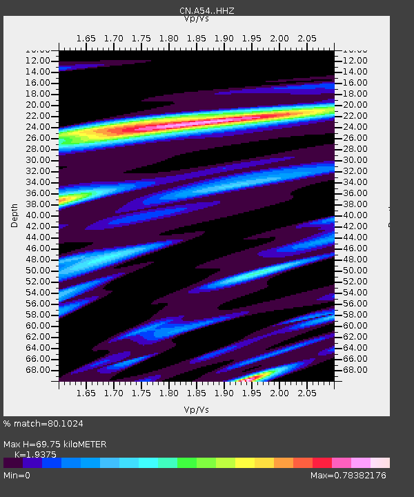
| Estimated Moho Depth: |
69.75 km |
| Estimated Crust Vp/Vs: |
1.94 |
| Assumed Crust Vp: |
6.61 km/s |
| Estimated Crust Vs: |
3.412 km/s |
| Estimated Crust Poisson's Ratio: |
0.32 |
|
| Radial Match: |
80.1024 % |
| Radial Bump: |
400 |
| Transverse Match: |
48.133083 % |
| Transverse Bump: |
400 |
| SOD ConfigId: |
7019011 |
| Insert Time: |
2019-04-16 18:08:52.182 +0000 |
| GWidth: |
2.5 |
| Max Bumps: |
400 |
| Tol: |
0.001 |
|

Signal To Noise
| Channel | StoN | STA | LTA |
| CN:A54: :HHZ:20150211T19:07:40.579985Z | 7.9860907 | 1.7222561E-6 | 2.1565697E-7 |
| CN:A54: :HHN:20150211T19:07:40.579985Z | 2.2966106 | 8.933976E-7 | 3.89007E-7 |
| CN:A54: :HHE:20150211T19:07:40.579985Z | 1.3273361 | 5.313242E-7 | 4.0029366E-7 |
| Arrivals |
| Ps | 10 SECOND |
| PpPs | 30 SECOND |
| PsPs/PpSs | 40 SECOND |


