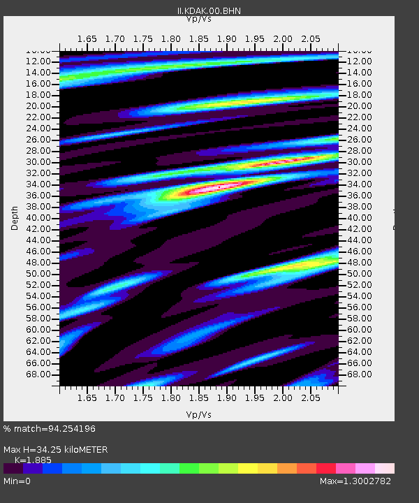
KDAK Kodiak Island, Alaska, USA - Earthquake Result Viewer

Earthquake location: Near East Coast Of Honshu, Japan
Earthquake latitude/longitude: 36.5/141.0
Earthquake time(UTC): 2000/07/20 (202) 18:39:18 GMT
Earthquake Depth: 47 km
Earthquake Magnitude: 6.1 MB, 5.4 MS, 6.1 ME, 6.0 MW
Earthquake Catalog/Contributor: WHDF/NEIC
Network: II Global Seismograph Network (GSN - IRIS/IDA)
Station: KDAK Kodiak Island, Alaska, USA
Lat/Lon: 57.78 N/152.58 W
Elevation: 152 m
Distance: 47.7 deg
Az: 41.58 deg
Baz: 273.513 deg
Ray Param: 0.06969648
Estimated Moho Depth: 34.25 km
Estimated Crust Vp/Vs: 1.88
Assumed Crust Vp: 6.134 km/s
Estimated Crust Vs: 3.254 km/s
Estimated Crust Poisson's Ratio: 0.30
Radial Match: 94.254196 %
Radial Bump: 400
Transverse Match: 84.61165 %
Transverse Bump: 400
SOD ConfigId: 3744
Insert Time: 2010-03-01 21:08:22.951 +0000
GWidth: 2.5
Max Bumps: 400
Tol: 0.001

Signal To Noise

ChannelStoNSTALTA
II:KDAK:00:BHN:20000720T18:47:20.42199Z5.3659323.4145725E-76.363429E-8
II:KDAK:00:BHE:20000720T18:47:20.42199Z13.6787137.379882E-75.395158E-8
II:KDAK:00:BHZ:20000720T18:47:20.42199Z35.820451.6628214E-64.6421007E-8
Arrivals
Ps5.2 SECOND
PpPs15 SECOND
PsPs/PpSs21 SECOND