You are here: Home > Network List > N4 - Central and EAstern US Network Stations List
> Station 250A Grady, AL, USA > Earthquake Result Viewer
250A Grady, AL, USA - Earthquake Result Viewer
| Earthquake location: |
Jujuy Province, Argentina |
| Earthquake latitude/longitude: |
-23.1/-66.7 |
| Earthquake time(UTC): |
2015/02/11 (042) 18:57:22 GMT |
| Earthquake Depth: |
223 km |
| Earthquake Magnitude: |
6.7 MWW, 6.7 MWC, 6.7 MWB, 6.9 MI |
| Earthquake Catalog/Contributor: |
NEIC PDE/NEIC COMCAT |
|
| Network: |
N4 Central and EAstern US Network |
| Station: |
250A Grady, AL, USA |
| Lat/Lon: |
31.98 N/86.27 W |
| Elevation: |
152 m |
|
| Distance: |
57.9 deg |
| Az: |
340.355 deg |
| Baz: |
158.64 deg |
| Ray Param: |
0.062458977 |
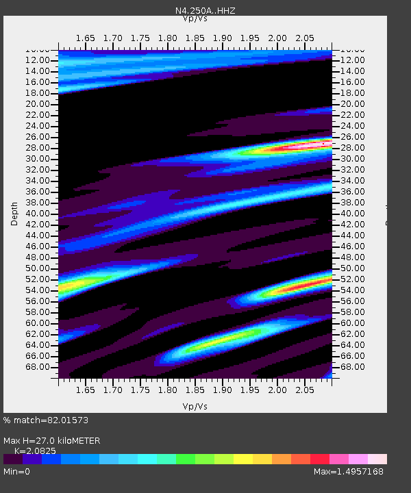
| Estimated Moho Depth: |
27.0 km |
| Estimated Crust Vp/Vs: |
2.08 |
| Assumed Crust Vp: |
6.187 km/s |
| Estimated Crust Vs: |
2.971 km/s |
| Estimated Crust Poisson's Ratio: |
0.35 |
|
| Radial Match: |
82.01573 % |
| Radial Bump: |
400 |
| Transverse Match: |
52.24713 % |
| Transverse Bump: |
400 |
| SOD ConfigId: |
7019011 |
| Insert Time: |
2019-04-16 18:11:16.621 +0000 |
| GWidth: |
2.5 |
| Max Bumps: |
400 |
| Tol: |
0.001 |
|

Signal To Noise
| Channel | StoN | STA | LTA |
| N4:250A: :HHZ:20150211T19:06:20.029998Z | 18.989279 | 5.8744245E-6 | 3.093548E-7 |
| N4:250A: :HHN:20150211T19:06:20.029998Z | 8.671486 | 4.4762087E-6 | 5.1619855E-7 |
| N4:250A: :HHE:20150211T19:06:20.029998Z | 3.0826283 | 2.2037925E-6 | 7.1490706E-7 |
| Arrivals |
| Ps | 4.9 SECOND |
| PpPs | 13 SECOND |
| PsPs/PpSs | 18 SECOND |


