You are here: Home > Network List > TA - USArray Transportable Network (new EarthScope stations) Stations List
> Station H17A Grant Village (NPS), Yellowstone Nt. Park, WY, USA > Earthquake Result Viewer
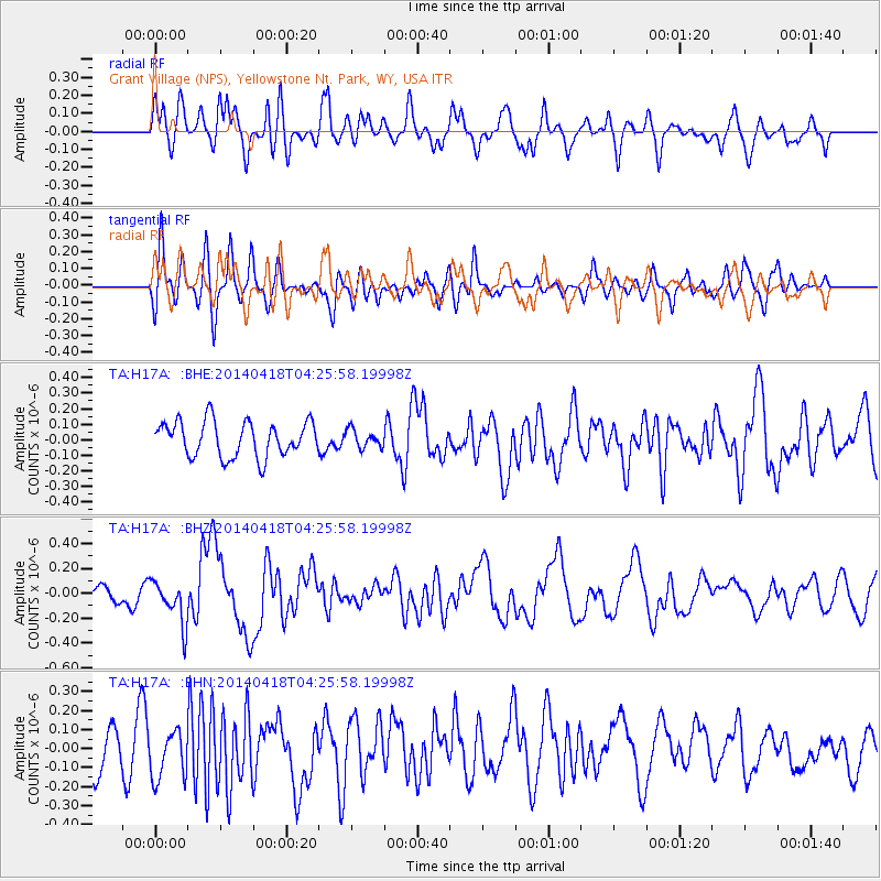
H17A Grant Village (NPS), Yellowstone Nt. Park, WY, USA - Earthquake Result Viewer
*The percent match for this event was below the threshold and hence no stack was calculated.
| Earthquake location: |
Santa Cruz Islands Region |
| Earthquake latitude/longitude: |
-11.2/164.8 |
| Earthquake time(UTC): |
2014/04/18 (108) 04:13:12 GMT |
| Earthquake Depth: |
10 km |
| Earthquake Magnitude: |
6.0 MB |
| Earthquake Catalog/Contributor: |
NEIC PDE/NEIC COMCAT |
|
| Network: |
TA USArray Transportable Network (new EarthScope stations) |
| Station: |
H17A Grant Village (NPS), Yellowstone Nt. Park, WY, USA |
| Lat/Lon: |
44.40 N/110.58 W |
| Elevation: |
2400 m |
|
| Distance: |
93.9 deg |
| Az: |
45.674 deg |
| Baz: |
258.32 deg |
| Ray Param: |
$rayparam |
*The percent match for this event was below the threshold and hence was not used in the summary stack. |
|
| Radial Match: |
50.62171 % |
| Radial Bump: |
400 |
| Transverse Match: |
48.573715 % |
| Transverse Bump: |
400 |
| SOD ConfigId: |
626651 |
| Insert Time: |
2014-05-02 04:46:02.442 +0000 |
| GWidth: |
2.5 |
| Max Bumps: |
400 |
| Tol: |
0.001 |
|
Signal To Noise
| Channel | StoN | STA | LTA |
| TA:H17A: :BHZ:20140418T04:25:58.19998Z | 2.755499 | 1.7284874E-7 | 6.272865E-8 |
| TA:H17A: :BHN:20140418T04:25:58.19998Z | 0.96752167 | 1.2465719E-7 | 1.2884176E-7 |
| TA:H17A: :BHE:20140418T04:25:58.19998Z | 0.50420195 | 5.7142927E-8 | 1.13333414E-7 |
| Arrivals |
| Ps | |
| PpPs | |
| PsPs/PpSs | |


