You are here: Home > Network List > TA - USArray Transportable Network (new EarthScope stations) Stations List
> Station HDA Harding Lake, AK, USA > Earthquake Result Viewer
HDA Harding Lake, AK, USA - Earthquake Result Viewer
| Earthquake location: |
Santa Cruz Islands Region |
| Earthquake latitude/longitude: |
-11.2/164.8 |
| Earthquake time(UTC): |
2014/04/18 (108) 04:13:12 GMT |
| Earthquake Depth: |
10 km |
| Earthquake Magnitude: |
6.0 MB |
| Earthquake Catalog/Contributor: |
NEIC PDE/NEIC COMCAT |
|
| Network: |
TA USArray Transportable Network (new EarthScope stations) |
| Station: |
HDA Harding Lake, AK, USA |
| Lat/Lon: |
64.41 N/146.95 W |
| Elevation: |
437 m |
|
| Distance: |
83.6 deg |
| Az: |
19.026 deg |
| Baz: |
227.444 deg |
| Ray Param: |
0.046040785 |
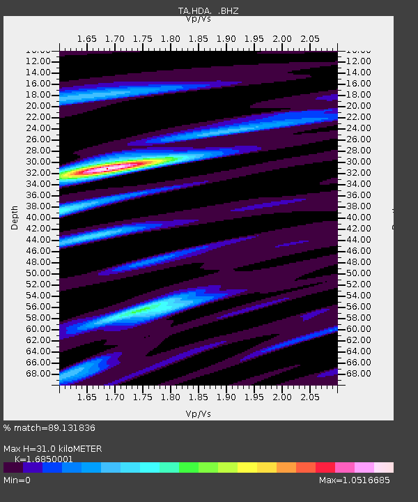
| Estimated Moho Depth: |
31.0 km |
| Estimated Crust Vp/Vs: |
1.69 |
| Assumed Crust Vp: |
6.566 km/s |
| Estimated Crust Vs: |
3.897 km/s |
| Estimated Crust Poisson's Ratio: |
0.23 |
|
| Radial Match: |
89.131836 % |
| Radial Bump: |
400 |
| Transverse Match: |
83.50715 % |
| Transverse Bump: |
400 |
| SOD ConfigId: |
626651 |
| Insert Time: |
2014-05-02 04:46:05.064 +0000 |
| GWidth: |
2.5 |
| Max Bumps: |
400 |
| Tol: |
0.001 |
|

Signal To Noise
| Channel | StoN | STA | LTA |
| TA:HDA: :BHZ:20140418T04:25:09.375029Z | 23.827406 | 1.7709009E-6 | 7.432202E-8 |
| TA:HDA: :BHN:20140418T04:25:09.375029Z | 2.7900496 | 3.075959E-7 | 1.1024748E-7 |
| TA:HDA: :BHE:20140418T04:25:09.375029Z | 8.5191 | 5.060708E-7 | 5.9404258E-8 |
| Arrivals |
| Ps | 3.3 SECOND |
| PpPs | 12 SECOND |
| PsPs/PpSs | 16 SECOND |


