You are here: Home > Network List > N4 - Central and EAstern US Network Stations List
> Station Q44B Vandalia, IL, USA > Earthquake Result Viewer
Q44B Vandalia, IL, USA - Earthquake Result Viewer
| Earthquake location: |
Jujuy Province, Argentina |
| Earthquake latitude/longitude: |
-23.1/-66.7 |
| Earthquake time(UTC): |
2015/02/11 (042) 18:57:22 GMT |
| Earthquake Depth: |
223 km |
| Earthquake Magnitude: |
6.7 MWW, 6.7 MWC, 6.7 MWB, 6.9 MI |
| Earthquake Catalog/Contributor: |
NEIC PDE/NEIC COMCAT |
|
| Network: |
N4 Central and EAstern US Network |
| Station: |
Q44B Vandalia, IL, USA |
| Lat/Lon: |
38.90 N/89.02 W |
| Elevation: |
168 m |
|
| Distance: |
65.1 deg |
| Az: |
340.932 deg |
| Baz: |
157.325 deg |
| Ray Param: |
0.05779497 |
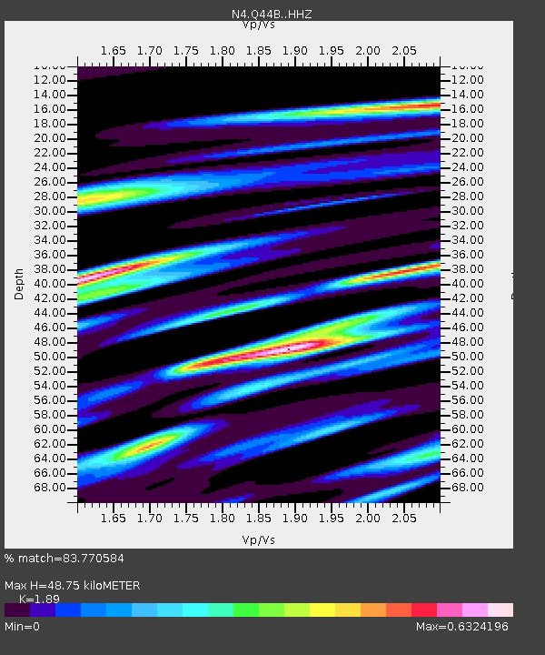
| Estimated Moho Depth: |
48.75 km |
| Estimated Crust Vp/Vs: |
1.89 |
| Assumed Crust Vp: |
6.444 km/s |
| Estimated Crust Vs: |
3.409 km/s |
| Estimated Crust Poisson's Ratio: |
0.31 |
|
| Radial Match: |
83.770584 % |
| Radial Bump: |
400 |
| Transverse Match: |
59.949726 % |
| Transverse Bump: |
400 |
| SOD ConfigId: |
7019011 |
| Insert Time: |
2019-04-16 18:12:10.652 +0000 |
| GWidth: |
2.5 |
| Max Bumps: |
400 |
| Tol: |
0.001 |
|

Signal To Noise
| Channel | StoN | STA | LTA |
| N4:Q44B: :HHZ:20150211T19:07:08.379973Z | 21.109886 | 4.448002E-6 | 2.1070707E-7 |
| N4:Q44B: :HHN:20150211T19:07:08.379973Z | 6.976483 | 2.055412E-6 | 2.946201E-7 |
| N4:Q44B: :HHE:20150211T19:07:08.379973Z | 3.7175663 | 9.730584E-7 | 2.617461E-7 |
| Arrivals |
| Ps | 7.0 SECOND |
| PpPs | 21 SECOND |
| PsPs/PpSs | 28 SECOND |


