You are here: Home > Network List > N4 - Central and EAstern US Network Stations List
> Station R40B Maddies Station, St. Elizabeth, MO, USA > Earthquake Result Viewer
R40B Maddies Station, St. Elizabeth, MO, USA - Earthquake Result Viewer
| Earthquake location: |
Jujuy Province, Argentina |
| Earthquake latitude/longitude: |
-23.1/-66.7 |
| Earthquake time(UTC): |
2015/02/11 (042) 18:57:22 GMT |
| Earthquake Depth: |
223 km |
| Earthquake Magnitude: |
6.7 MWW, 6.7 MWC, 6.7 MWB, 6.9 MI |
| Earthquake Catalog/Contributor: |
NEIC PDE/NEIC COMCAT |
|
| Network: |
N4 Central and EAstern US Network |
| Station: |
R40B Maddies Station, St. Elizabeth, MO, USA |
| Lat/Lon: |
38.29 N/92.27 W |
| Elevation: |
218 m |
|
| Distance: |
65.6 deg |
| Az: |
338.101 deg |
| Baz: |
154.125 deg |
| Ray Param: |
0.057477124 |
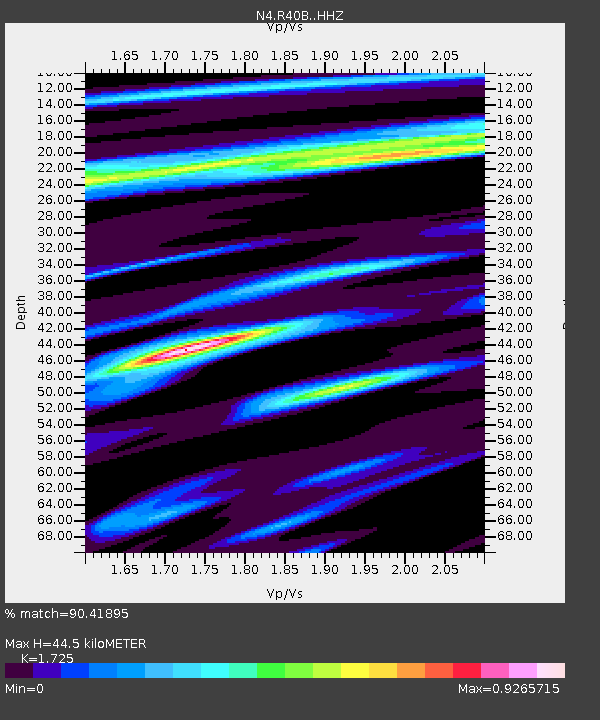
| Estimated Moho Depth: |
44.5 km |
| Estimated Crust Vp/Vs: |
1.73 |
| Assumed Crust Vp: |
6.498 km/s |
| Estimated Crust Vs: |
3.767 km/s |
| Estimated Crust Poisson's Ratio: |
0.25 |
|
| Radial Match: |
90.41895 % |
| Radial Bump: |
358 |
| Transverse Match: |
59.965515 % |
| Transverse Bump: |
400 |
| SOD ConfigId: |
7019011 |
| Insert Time: |
2019-04-16 18:12:14.655 +0000 |
| GWidth: |
2.5 |
| Max Bumps: |
400 |
| Tol: |
0.001 |
|

Signal To Noise
| Channel | StoN | STA | LTA |
| N4:R40B: :HHZ:20150211T19:07:11.529998Z | 19.202293 | 4.724573E-6 | 2.460421E-7 |
| N4:R40B: :HHN:20150211T19:07:11.529998Z | 6.3818097 | 1.5033568E-6 | 2.3556905E-7 |
| N4:R40B: :HHE:20150211T19:07:11.529998Z | 6.1656857 | 1.020817E-6 | 1.6556423E-7 |
| Arrivals |
| Ps | 5.2 SECOND |
| PpPs | 18 SECOND |
| PsPs/PpSs | 23 SECOND |


