You are here: Home > Network List > TA - USArray Transportable Network (new EarthScope stations) Stations List
> Station N23A Red Feather Lakes, CO, USA > Earthquake Result Viewer
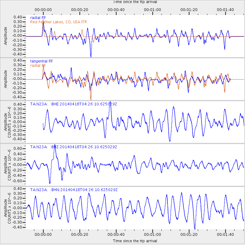
N23A Red Feather Lakes, CO, USA - Earthquake Result Viewer
*The percent match for this event was below the threshold and hence no stack was calculated.
| Earthquake location: |
Santa Cruz Islands Region |
| Earthquake latitude/longitude: |
-11.2/164.8 |
| Earthquake time(UTC): |
2014/04/18 (108) 04:13:12 GMT |
| Earthquake Depth: |
10 km |
| Earthquake Magnitude: |
6.0 MB |
| Earthquake Catalog/Contributor: |
NEIC PDE/NEIC COMCAT |
|
| Network: |
TA USArray Transportable Network (new EarthScope stations) |
| Station: |
N23A Red Feather Lakes, CO, USA |
| Lat/Lon: |
40.89 N/105.94 W |
| Elevation: |
2458 m |
|
| Distance: |
96.6 deg |
| Az: |
49.742 deg |
| Baz: |
261.075 deg |
| Ray Param: |
$rayparam |
*The percent match for this event was below the threshold and hence was not used in the summary stack. |
|
| Radial Match: |
61.465965 % |
| Radial Bump: |
400 |
| Transverse Match: |
39.051826 % |
| Transverse Bump: |
328 |
| SOD ConfigId: |
626651 |
| Insert Time: |
2014-05-02 04:46:45.309 +0000 |
| GWidth: |
2.5 |
| Max Bumps: |
400 |
| Tol: |
0.001 |
|
Signal To Noise
| Channel | StoN | STA | LTA |
| TA:N23A: :BHZ:20140418T04:26:10.625029Z | 2.8583956 | 2.5591143E-7 | 8.952975E-8 |
| TA:N23A: :BHN:20140418T04:26:10.625029Z | 1.0575988 | 1.2954693E-7 | 1.2249157E-7 |
| TA:N23A: :BHE:20140418T04:26:10.625029Z | 1.2154 | 1.3546175E-7 | 1.1145447E-7 |
| Arrivals |
| Ps | |
| PpPs | |
| PsPs/PpSs | |


