You are here: Home > Network List > N4 - Central and EAstern US Network Stations List
> Station T47A Sharon Grove, KY, USA > Earthquake Result Viewer
T47A Sharon Grove, KY, USA - Earthquake Result Viewer
| Earthquake location: |
Jujuy Province, Argentina |
| Earthquake latitude/longitude: |
-23.1/-66.7 |
| Earthquake time(UTC): |
2015/02/11 (042) 18:57:22 GMT |
| Earthquake Depth: |
223 km |
| Earthquake Magnitude: |
6.7 MWW, 6.7 MWC, 6.7 MWB, 6.9 MI |
| Earthquake Catalog/Contributor: |
NEIC PDE/NEIC COMCAT |
|
| Network: |
N4 Central and EAstern US Network |
| Station: |
T47A Sharon Grove, KY, USA |
| Lat/Lon: |
36.99 N/87.11 W |
| Elevation: |
217 m |
|
| Distance: |
62.8 deg |
| Az: |
341.698 deg |
| Baz: |
158.832 deg |
| Ray Param: |
0.059299756 |
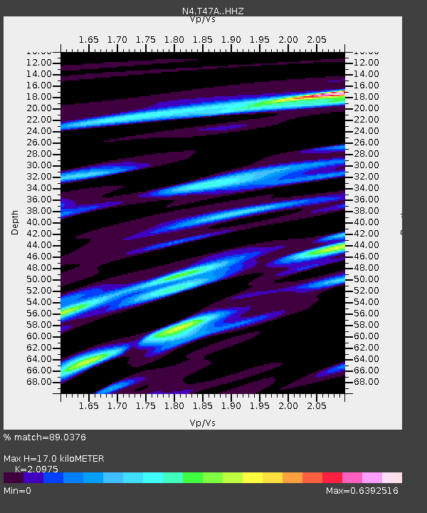
| Estimated Moho Depth: |
17.0 km |
| Estimated Crust Vp/Vs: |
2.10 |
| Assumed Crust Vp: |
6.444 km/s |
| Estimated Crust Vs: |
3.072 km/s |
| Estimated Crust Poisson's Ratio: |
0.35 |
|
| Radial Match: |
89.0376 % |
| Radial Bump: |
337 |
| Transverse Match: |
61.837364 % |
| Transverse Bump: |
400 |
| SOD ConfigId: |
7019011 |
| Insert Time: |
2019-04-16 18:12:23.414 +0000 |
| GWidth: |
2.5 |
| Max Bumps: |
400 |
| Tol: |
0.001 |
|

Signal To Noise
| Channel | StoN | STA | LTA |
| N4:T47A: :HHZ:20150211T19:06:53.189971Z | 24.031572 | 5.9672325E-6 | 2.4830806E-7 |
| N4:T47A: :HHN:20150211T19:06:53.189971Z | 10.518264 | 2.634686E-6 | 2.5048678E-7 |
| N4:T47A: :HHE:20150211T19:06:53.189971Z | 4.14331 | 1.1910935E-6 | 2.874739E-7 |
| Arrivals |
| Ps | 3.0 SECOND |
| PpPs | 7.9 SECOND |
| PsPs/PpSs | 11 SECOND |


