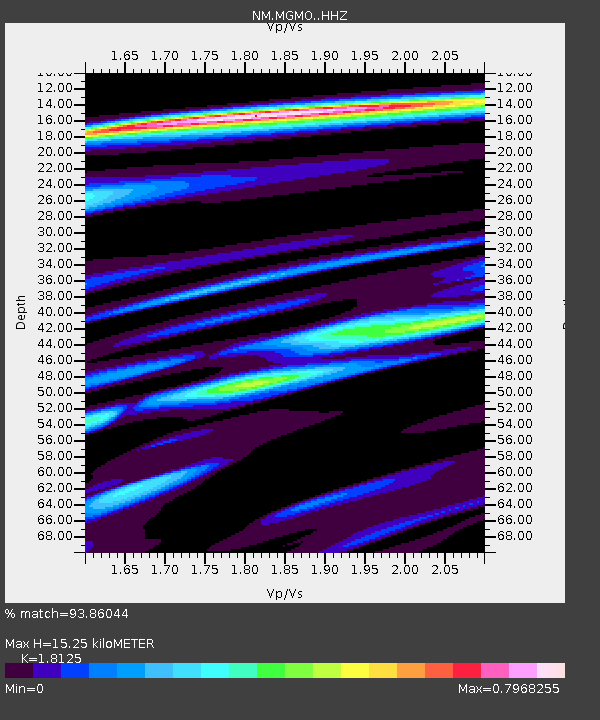
MGMO Mountain Grove, MO - Earthquake Result Viewer

Earthquake location: Jujuy Province, Argentina
Earthquake latitude/longitude: -23.1/-66.7
Earthquake time(UTC): 2015/02/11 (042) 18:57:22 GMT
Earthquake Depth: 223 km
Earthquake Magnitude: 6.7 MWW, 6.7 MWC, 6.7 MWB, 6.9 MI
Earthquake Catalog/Contributor: NEIC PDE/NEIC COMCAT
Network: NM Cooperative New Madrid Seismic Network
Station: MGMO Mountain Grove, MO
Lat/Lon: 37.15 N/92.27 W
Elevation: 453 m
Distance: 64.6 deg
Az: 337.552 deg
Baz: 153.894 deg
Ray Param: 0.05813718
Estimated Moho Depth: 15.25 km
Estimated Crust Vp/Vs: 1.81
Assumed Crust Vp: 6.53 km/s
Estimated Crust Vs: 3.603 km/s
Estimated Crust Poisson's Ratio: 0.28
Radial Match: 93.86044 %
Radial Bump: 349
Transverse Match: 80.77942 %
Transverse Bump: 400
SOD ConfigId: 7019011
Insert Time: 2019-04-16 18:13:13.269 +0000
GWidth: 2.5
Max Bumps: 400
Tol: 0.001

Signal To Noise

ChannelStoNSTALTA
NM:MGMO: :HHZ:20150211T19:07:04.988005Z19.103144.5968236E-62.4063183E-7
NM:MGMO: :HHN:20150211T19:07:04.988005Z8.9517351.7783252E-61.9865706E-7
NM:MGMO: :HHE:20150211T19:07:04.988005Z4.0971477.595323E-71.8538078E-7
Arrivals
Ps2.0 SECOND
PpPs6.3 SECOND
PsPs/PpSs8.3 SECOND