You are here: Home > Network List > UW - Pacific Northwest Regional Seismic Network Stations List
> Station PASS Maple Falls, WA, USA > Earthquake Result Viewer
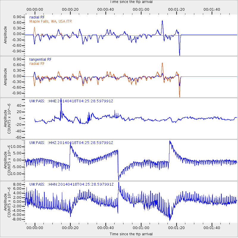
PASS Maple Falls, WA, USA - Earthquake Result Viewer
*The percent match for this event was below the threshold and hence no stack was calculated.
| Earthquake location: |
Santa Cruz Islands Region |
| Earthquake latitude/longitude: |
-11.2/164.8 |
| Earthquake time(UTC): |
2014/04/18 (108) 04:13:12 GMT |
| Earthquake Depth: |
10 km |
| Earthquake Magnitude: |
6.0 MB |
| Earthquake Catalog/Contributor: |
NEIC PDE/NEIC COMCAT |
|
| Network: |
UW Pacific Northwest Regional Seismic Network |
| Station: |
PASS Maple Falls, WA, USA |
| Lat/Lon: |
49.00 N/122.09 W |
| Elevation: |
174 m |
|
| Distance: |
87.5 deg |
| Az: |
39.106 deg |
| Baz: |
250.033 deg |
| Ray Param: |
$rayparam |
*The percent match for this event was below the threshold and hence was not used in the summary stack. |
|
| Radial Match: |
41.4773 % |
| Radial Bump: |
400 |
| Transverse Match: |
45.853245 % |
| Transverse Bump: |
375 |
| SOD ConfigId: |
626651 |
| Insert Time: |
2014-05-02 04:51:56.189 +0000 |
| GWidth: |
2.5 |
| Max Bumps: |
400 |
| Tol: |
0.001 |
|
Signal To Noise
| Channel | StoN | STA | LTA |
| UW:PASS: :HHZ:20140418T04:25:28.597991Z | 1.2557601 | 1.7690833E-6 | 1.4087749E-6 |
| UW:PASS: :HHN:20140418T04:25:28.597991Z | 1.5343505 | 2.9057899E-6 | 1.8938241E-6 |
| UW:PASS: :HHE:20140418T04:25:28.597991Z | 1.1081879 | 1.0449811E-5 | 9.429638E-6 |
| Arrivals |
| Ps | |
| PpPs | |
| PsPs/PpSs | |


