You are here: Home > Network List > II - Global Seismograph Network (GSN - IRIS/IDA) Stations List
> Station KDAK Kodiak Island, Alaska, USA > Earthquake Result Viewer
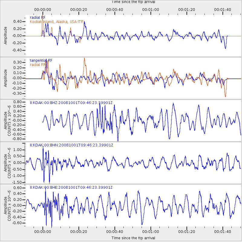
KDAK Kodiak Island, Alaska, USA - Earthquake Result Viewer
*The percent match for this event was below the threshold and hence no stack was calculated.
| Earthquake location: |
Southeast Of Honshu, Japan |
| Earthquake latitude/longitude: |
30.2/138.8 |
| Earthquake time(UTC): |
2008/10/01 (275) 09:38:12 GMT |
| Earthquake Depth: |
414 km |
| Earthquake Magnitude: |
5.7 MW, 5.1 MB, 5.7 MW |
| Earthquake Catalog/Contributor: |
WHDF/NEIC |
|
| Network: |
II Global Seismograph Network (GSN - IRIS/IDA) |
| Station: |
KDAK Kodiak Island, Alaska, USA |
| Lat/Lon: |
57.78 N/152.58 W |
| Elevation: |
152 m |
|
| Distance: |
53.8 deg |
| Az: |
38.211 deg |
| Baz: |
270.102 deg |
| Ray Param: |
$rayparam |
*The percent match for this event was below the threshold and hence was not used in the summary stack. |
|
| Radial Match: |
41.197006 % |
| Radial Bump: |
400 |
| Transverse Match: |
49.493916 % |
| Transverse Bump: |
400 |
| SOD ConfigId: |
2556 |
| Insert Time: |
2010-03-01 21:09:45.050 +0000 |
| GWidth: |
2.5 |
| Max Bumps: |
400 |
| Tol: |
0.001 |
|
Signal To Noise
| Channel | StoN | STA | LTA |
| II:KDAK:00:BHN:20081001T09:46:23.39901Z | 3.3880424 | 6.764811E-7 | 1.9966723E-7 |
| II:KDAK:00:BHE:20081001T09:46:23.39901Z | 1.469578 | 2.296144E-7 | 1.5624512E-7 |
| II:KDAK:00:BHZ:20081001T09:46:23.39901Z | 1.8275576 | 4.238942E-7 | 2.3194573E-7 |
| Arrivals |
| Ps | |
| PpPs | |
| PsPs/PpSs | |


