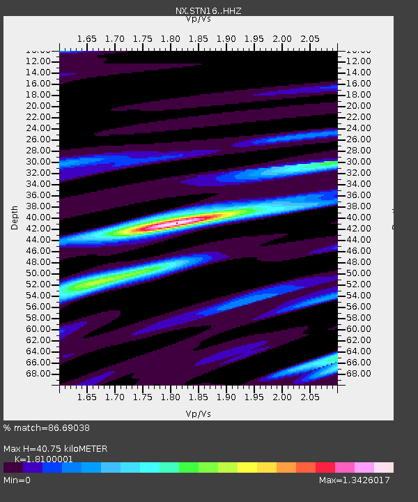
STN16 Seismic station 16 - Earthquake Result Viewer

Earthquake location: Jujuy Province, Argentina
Earthquake latitude/longitude: -23.1/-66.7
Earthquake time(UTC): 2015/02/11 (042) 18:57:22 GMT
Earthquake Depth: 223 km
Earthquake Magnitude: 6.7 MWW, 6.7 MWC, 6.7 MWB, 6.9 MI
Earthquake Catalog/Contributor: NEIC PDE/NEIC COMCAT
Network: NX Nanometrics Research Network
Station: STN16 Seismic station 16
Lat/Lon: 36.35 N/97.13 W
Elevation: 294 m
Distance: 65.8 deg
Az: 333.351 deg
Baz: 149.234 deg
Ray Param: 0.05739046
Estimated Moho Depth: 40.75 km
Estimated Crust Vp/Vs: 1.81
Assumed Crust Vp: 6.483 km/s
Estimated Crust Vs: 3.582 km/s
Estimated Crust Poisson's Ratio: 0.28
Radial Match: 86.69038 %
Radial Bump: 400
Transverse Match: 75.460335 %
Transverse Bump: 400
SOD ConfigId: 7019011
Insert Time: 2019-04-16 18:13:56.721 +0000
GWidth: 2.5
Max Bumps: 400
Tol: 0.001

Signal To Noise

ChannelStoNSTALTA
NX:STN16: :HHZ:20150211T19:07:12.399993Z27.4852395.5313735E-62.0124888E-7
NX:STN16: :HH1:20150211T19:07:12.399993Z9.8861072.0090956E-62.0322413E-7
NX:STN16: :HH2:20150211T19:07:12.399993Z6.9156541.6806054E-62.4301465E-7
Arrivals
Ps5.3 SECOND
PpPs17 SECOND
PsPs/PpSs22 SECOND