You are here: Home > Network List > AK - Alaska Regional Network Stations List
> Station BRSE Bradley Lake South, AK, USA > Earthquake Result Viewer
BRSE Bradley Lake South, AK, USA - Earthquake Result Viewer
| Earthquake location: |
Guerrero, Mexico |
| Earthquake latitude/longitude: |
17.6/-100.8 |
| Earthquake time(UTC): |
2014/04/18 (108) 14:27:26 GMT |
| Earthquake Depth: |
24 km |
| Earthquake Magnitude: |
7.2 MWW, 7.0 MWB, 7.3 MWC, 7.5 MI |
| Earthquake Catalog/Contributor: |
NEIC PDE/NEIC COMCAT |
|
| Network: |
AK Alaska Regional Network |
| Station: |
BRSE Bradley Lake South, AK, USA |
| Lat/Lon: |
59.74 N/150.74 W |
| Elevation: |
541 m |
|
| Distance: |
55.3 deg |
| Az: |
331.872 deg |
| Baz: |
117.363 deg |
| Ray Param: |
0.064857915 |
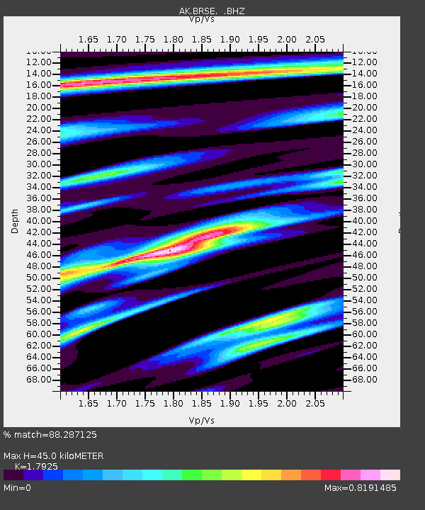
| Estimated Moho Depth: |
45.0 km |
| Estimated Crust Vp/Vs: |
1.79 |
| Assumed Crust Vp: |
6.24 km/s |
| Estimated Crust Vs: |
3.481 km/s |
| Estimated Crust Poisson's Ratio: |
0.27 |
|
| Radial Match: |
88.287125 % |
| Radial Bump: |
397 |
| Transverse Match: |
87.690865 % |
| Transverse Bump: |
400 |
| SOD ConfigId: |
626651 |
| Insert Time: |
2014-05-02 14:37:40.539 +0000 |
| GWidth: |
2.5 |
| Max Bumps: |
400 |
| Tol: |
0.001 |
|

Signal To Noise
| Channel | StoN | STA | LTA |
| AK:BRSE: :BHZ:20140418T14:36:27.047988Z | 68.73379 | 1.1905342E-5 | 1.7320946E-7 |
| AK:BRSE: :BHN:20140418T14:36:27.047988Z | 21.218624 | 2.1743197E-6 | 1.0247223E-7 |
| AK:BRSE: :BHE:20140418T14:36:27.047988Z | 39.013428 | 5.642793E-6 | 1.446372E-7 |
| Arrivals |
| Ps | 6.0 SECOND |
| PpPs | 19 SECOND |
| PsPs/PpSs | 25 SECOND |


